AT 200 PM AST...1800Z...THE CENTER OF SUBTROPICAL STORM GABRIELLE
WAS LOCATED NEAR LATITUDE 31.8 NORTH...LONGITUDE 74.1 WEST OR ABOUT
240 MILES...385 KM...SOUTHEAST OF CAPE LOOKOUT NORTH CAROLINA.
THE CENTER OF GABRIELLE HAS BEEN MOVING ERRATICALLY DURING THE PAST
FEW HOURS BUT IS MOVING GENERALLY TOWARD THE NORTHWEST NEAR 9
MPH...14 KM/HR. A CONTINUED NORTHWESTWARD MOTION WITH A SLIGHT
DECREASE IN FORWARD SPEED IS EXPECTED DURING THE NEXT 24 HOURS. ON
THIS TRACK...THE CENTER OF GABRIELLE WILL NEAR THE COAST OF NORTH
CAROLINA TOMORROW...BUT OUTER RAIN BANDS WILL LIKELY REACH THE
COAST TONIGHT.
MAXIMUM SUSTAINED WINDS ARE NEAR 45 MPH...75 KM/HR...WITH HIGHER
GUSTS. SLIGHT STRENGTHENING IS FORECAST DURING THE NEXT 24 HOURS AS
GABRIELLE ACQUIRES MORE TROPICAL CHARACTERISTICS.
WINDS OF 40 MPH EXTEND OUTWARD UP TO 115 MILES...185 KM TO THE NORTH
FROM THE CENTER.
THE MINIMUM CENTRAL PRESSURE BASED ON REPORTS FROM AN AIR FORCE
RECONNAISSANCE AIRCRAFT IS 1009 MB...29.80 INCHES.
Saturday, September 8, 2007
Gabrielle
Sunday, September 2, 2007
Henriette (Eastern Pacific)

AT 800 PM PDT...0300Z...THE CENTER OF TROPICAL STORM HENRIETTE WAS
LOCATED NEAR LATITUDE 18.4 NORTH...LONGITUDE 106.1 WEST OR ABOUT 125
MILES...200 KM...WEST-SOUTHWEST OF MANZANILLO MEXICO AND ABOUT 395
MILES...640 KM...SOUTHEAST OF THE SOUTHERN TIP OF BAJA CALIFORNIA.
HENRIETTE IS MOVING TOWARD THE WEST-NORTHWEST NEAR 10 MPH...17 KM/HR
...AND THIS MOTION IS EXPECTED TO CONTINUE FOR THE NEXT 24 HOURS.
THIS MOTION SHOULD BRING THE CENTER OF HENRIETTE AWAY FROM THE
MAINLAND OF MEXICO TONIGHT AND SUNDAY.
MAXIMUM SUSTAINED WINDS ARE NEAR 70 MPH...110 KM/HR...WITH HIGHER
GUSTS. SOME STRENGTHENING IS FORECAST DURING THE NEXT 24 HOURS
AND HENRIETTE IS FORECAST TO BECOME A HURRICANE ON SUNDAY.
TROPICAL STORM FORCE WINDS EXTEND OUTWARD UP TO 85 MILES...140 KM
FROM THE CENTER.
ESTIMATED MINIMUM CENTRAL PRESSURE IS 994 MB...29.35 INCHES.
Felix: Update #1

AT 1100 AM AST...1500Z...THE CENTER OF HURRICANE FELIX WAS LOCATED
NEAR LATITUDE 13.2 NORTH...LONGITUDE 70.1 WEST OR ABOUT 50 MILES...
75 KM...NORTH OF ARUBA AND ABOUT 555 MILES...895 KM...SOUTHEAST OF
KINGSTON JAMAICA.
FELIX IS MOVING TOWARD THE WEST-NORTHWEST NEAR 18 MPH...30 KM/HR...
AND THIS GENERAL MOTION IS EXPECTED TO CONTINUE FOR THE NEXT 24
HOURS. ON THIS TRACK THE CENTER OF THE HURRICANE WILL BE MOVING
AWAY FROM THE NETHERLANDS ANTILLES AND OVER THE OPEN WATERS OF THE
CENTRAL CARIBBEAN SEA TODAY AND TONIGHT.
MAXIMUM SUSTAINED WINDS ARE NEAR 105 MPH...165 KM/HR...WITH HIGHER
GUSTS. FELIX IS A CATEGORY TWO HURRICANE ON THE SAFFIR-SIMPSON
SCALE. STRENGTHENING IS FORECAST AND FELIX COULD BECOME A MAJOR
HURRICANE TONIGHT OR EARLY ON MONDAY.
HURRICANE FORCE WINDS EXTEND OUTWARD UP TO 15 MILES...30 KM...FROM
THE CENTER...AND TROPICAL STORM FORCE WINDS EXTEND OUTWARD UP TO 115
MILES...185 KM.
ESTIMATED MINIMUM CENTRAL PRESSURE IS 980 MB...28.94 INCHES.
Saturday, September 1, 2007
Felix
AT 1100 AM AST...1500Z...THE CENTER OF TROPICAL STORM FELIX WAS
LOCATED NEAR LATITUDE 12.3 NORTH...LONGITUDE 63.6 WEST OR ABOUT 455
MILES...730 KM...SOUTH-SOUTHEAST OF SAN JUAN PUERTO RICO AND ABOUT
600 MILES...965 KM...SOUTHEAST OF SANTO DOMINGO IN THE DOMINICAN
REPUBLIC.
FELIX IS MOVING TOWARD THE WEST NEAR 18 MPH...30 KM/HR...AND THIS
GENERAL MOTION IS EXPECTED TO CONTINUE DURING THE NEXT 24 HOURS.
ON THIS TRACK...FELIX WILL BE PASSING NEAR OR TO THE NORTH OF THE
ISLANDS OF ARUBA...BONAIRE AND CURACAO LATE TONIGHT OR EARLY SUNDAY
MORNING.
MAXIMUM SUSTAINED WINDS HAVE INCREASED TO NEAR 65 MPH...100
KM/HR...WITH HIGHER GUSTS. FELIX COULD BECOME A HURRICANE ON
SUNDAY.
TROPICAL STORM FORCE WINDS EXTEND OUTWARD UP TO 45 MILES...75 KM
FROM THE CENTER.
THE MINIMUM CENTRAL PRESSURE REPORTED BY AN AIR FORCE RESERVE
HURRICANE HUNTER PLANE WAS 1001 MB...29.56 INCHES.
Friday, August 31, 2007
TD #6

AT 500 PM AST...2100Z...THE CENTER OF THE NEWLY FORMED TROPICAL
DEPRESSION SIX WAS LOCATED NEAR LATITUDE 11.8 NORTH...LONGITUDE
58.6 WEST OR ABOUT 180 MILES...295 KM...EAST-SOUTHEAST OF THE
WINDWARD ISLANDS.
THE DEPRESSION IS MOVING TOWARD THE WEST NEAR 16 MPH AND THIS
GENERAL MOTION IS EXPECTED TO CONTINUE FOR THE NEXT 24 HOURS. ON
THIS TRACK...THE DEPRESSION WILL BE PASSING THROUGH THE WINDWARD
ISLANDS OVERNIGHT.
MAXIMUM SUSTAINED WINDS ARE NEAR 35 MPH...55 KM/HR...WITH HIGHER
GUSTS. THE DEPRESSION COULD BECOME A TROPICAL STORM ON SATURDAY.
THE ESTIMATED MINIMUM CENTRAL PRESSURE FROM SURFACE OBSERVATIONS AND
AN AIR FORCE RESERVE HURRICANE HUNTER IS 1008 MB...29.77 INCHES.

Wednesday, August 22, 2007
Dean The Sequel
MAXIMUM SUSTAINED WINDS HAVE INCREASED AND ARE NOW NEAR 100
MPH...160 KM/HR...WITH HIGHER GUSTS. DEAN IS A CATEGORY TWO
HURRICANE ON THE SAFFIR-SIMPSON SCALE. ONLY A SMALL AMOUNT OF
ADDITIONAL STRENGTHENING IS LIKELY PRIOR TO LANDFALL.
HURRICANE FORCE WINDS EXTEND OUTWARD UP TO 70 MILES...110 KM...FROM
THE CENTER...AND TROPICAL STORM FORCE WINDS EXTEND OUTWARD UP TO 200
MILES...325 KM.
THE LATEST MINIMUM CENTRAL PRESSURE REPORTED BY AN AIR FORCE RESERVE
UNIT RECONNAISSANCE AIRCRAFT WAS 979 MB...28.91 INCHES.
Tuesday, August 21, 2007
Yet More Rank Stupidity
It had to be coming.
Bullshit. Complete intellectually dishonest bullshit.
The truth is we only have complete data on intensity from the late 1960's. For example, look at the data for 1960. Of the seven tropical storms that season only three have recorded pressure readings, and one of those seems suspect to me. (Category 5 hurricane Ethel only had a pressure of 981mb?)
Or check out 1950, where only three of 13 storms have pressure readings. This includes no pressure reading on the massive category 5 storm Dog.

How do we know this wasn't one of the strongest storms ever? We don't. Our data isn't good enough.
Unfortunately, this type of unscientific demagoguery is par for the course with the GW hysteria crowd.
No one storm says anything about climate change; but nevertheless, climate change may affect weather in the aggregate. ... bearing in mind the scientific expectation that global warming ought to intensify the average hurricane (by how much remains hotly disputed). How does Dean fit into that ongoing scientific argument? Well, first of all, Dean now takes its rank among the top ten most intense Atlantic hurricanes. If you look at that list you’ll see that six of the strongest (Wilma, Rita, Katrina, Mitch, Dean, and Ivan) have been in the past ten years. That’s not the kind of statistic that’s easy to overlook. According to these data we are getting stronger storms in the Atlantic basin now than we ever have before.
Bullshit. Complete intellectually dishonest bullshit.
The truth is we only have complete data on intensity from the late 1960's. For example, look at the data for 1960. Of the seven tropical storms that season only three have recorded pressure readings, and one of those seems suspect to me. (Category 5 hurricane Ethel only had a pressure of 981mb?)
Or check out 1950, where only three of 13 storms have pressure readings. This includes no pressure reading on the massive category 5 storm Dog.
How do we know this wasn't one of the strongest storms ever? We don't. Our data isn't good enough.
Unfortunately, this type of unscientific demagoguery is par for the course with the GW hysteria crowd.
Monday, August 20, 2007
Cat 5 Dean Zeroes In On Yucatan
1100 PM EDT MON AUG 20 2007
...EYE OF POTENTIALLY CATASTROPHIC HURRICANE DEAN JUST A FEW HOURS
FROM LANDFALL ALONG THE EAST COAST OF THE YUCATAN PENINSULA...
...
MAXIMUM SUSTAINED WINDS ARE NEAR 160 MPH...260 KM/HR...WITH HIGHER
GUSTS. DEAN IS A POTENTIALLY CATASTROPHIC CATEGORY FIVE HURRICANE
ON THE SAFFIR-SIMPSON HURRICANE SCALE. LITTLE CHANGE IN STRENGTH
IS EXPECTED PRIOR TO LANDFALL ON THE EAST COAST OF THE YUCATAN
PENINSULA. ALTHOUGH SOME WEAKENING IS FORECAST AS DEAN CROSSES THE
YUCATAN PENINSULA...DEAN IS EXPECTED TO MAINTAIN HURRICANE STRENGTH
THROUGHOUT THE NEXT 24 HOURS.
HURRICANE FORCE WINDS EXTEND OUTWARD UP TO 60 MILES...95 KM...FROM
THE CENTER...AND TROPICAL STORM FORCE WINDS EXTEND OUTWARD UP TO 175
MILES...280 KM.
THE MOST RECENT MINIMUM CENTRAL PRESSURE MEASURED BY AN AIR FORCE
RESERVE RECONNAISSANCE AIRCRAFT WAS 914 MB...26.99 INCHES.
DEAN IS EXPECTED TO PRODUCE STORM TOTAL RAINFALL OF 5 TO 10 INCHES
OVER THE ISTHMUS OF TEHUANTEPEC AND YUCATAN PENINSULA OF
MEXICO...BELIZE...GUATEMALA...AND NORTHERN HONDURAS...WITH MAXIMUM
AMOUNTS OF UP TO 20 INCHES. THESE RAINS COULD CAUSE
LIFE-THREATENING FLASH FLOODS AND MUD SLIDES.
STORM SURGE FLOODING OF 12 TO 18 FEET ABOVE NORMAL TIDE LEVELS IS
POSSIBLE NEAR AND TO THE NORTH OF WHERE DEAN MAKES LANDFALL ALONG
THE EAST COAST OF THE YUCATAN PENINSULA.
Coastal flooding could be horrendous, and flimsy construction in the poorer areas of the Yucatan will be severely hit. Good luck to all our friends in Mexico. Stay safe.
Sunday, August 19, 2007
Some Good News On Dean
Dean is a little less intense today.
When the eye of a hurricane increases in size it can often indicate a lessening of strength, at least in the short term. Dean has been a very compact, tightly wound storm up until now.
It should be noted that the official statement differs from the "discussion" statement I quoted above:
This makes sense as you never want people to let up their guard, especially as the storm is about to slam into a populated area.
1100 AM EDT SUN AUG 19 2007
THE HURRICANE HUNTER AIRCRAFT REPORTED A PEAK FLIGHT-LEVEL WIND OF
142 KT IN THE NORTHWEST QUADRANT...WHICH WOULD SUPPORT THE CURRENT
ESTIMATED INTENSITY OF 125 KT. CENTRAL PRESSURES HAVE BEEN SLOWLY
RISING...THE EYE DIAMETER HAS INCREASED OVER THE PAST 12
HOURS...AND THE RECONNAISSANCE DATA INDICATE A CONCENTRIC EYEWALL
STRUCTURE. IN THE SHORT TERM...THERE COULD BE SOME BROADENING OF
THE WIND FIELD WITH FLUCTUATIONS IN STRENGTH AS THE CORE OF DEAN
APPROACHES JAMAICA...BUT FURTHER STRENGTHENING OVER THE DEEP WARM
WATERS OF THE NORTHWESTERN CARIBBEAN IS EXPECTED.
When the eye of a hurricane increases in size it can often indicate a lessening of strength, at least in the short term. Dean has been a very compact, tightly wound storm up until now.
It should be noted that the official statement differs from the "discussion" statement I quoted above:
MAXIMUM SUSTAINED WINDS ARE NEAR 145 MPH...230 KM/HR...WITH HIGHER
GUSTS. DEAN IS A CATEGORY FOUR HURRICANE ON THE SAFFIR-SIMPSON
SCALE. FLUCTUATIONS IN INTENSITY ARE COMMON IN MAJOR HURRICANES AND
ARE POSSIBLE DURING THE NEXT 24 HOURS.
This makes sense as you never want people to let up their guard, especially as the storm is about to slam into a populated area.
Saturday, August 18, 2007
Jamaica Prepares For Dean
From the Jamaica Observer: Dean on course
With storms this size you sometimes don't know exactly what you are going to get. Dean has had a relatively small area of hurricane force winds to this point so it wouldn't take a huge jog to the north or south to spare Jamaica the worst. However, a direct hit seems likeliest right now.
Good luck to all in Jamaica.
THE island's emergency response agencies were yesterday put on full alert as the country braced for what is likely to be a direct hit from Hurricane Dean.
Dean, which yesterday morning pounded the Eastern Caribbean islands of Martinique, Dominica and St Lucia, last night strengthened to a category four hurricane and was on a path that would take it over Jamaica by early tomorrow.
At 8:00 last night, Dean, packing winds of 135 miles per hour, (mph) was approximately 800 miles east-southeast of Kingston, the Jamaican capital. The hurricane was moving towards the west at a slow 19 mph, and was forecast to continue on that course today, with a decrease in forward speed. However, the National Hurricane Center in Miami said the weather system was likely to strengthen as it moved closer to Jamaica.
In preparation for Dean, Prime Minister Portia Simpson Miller, following a three-hour meeting with the National Disaster Committee yesterday, said police officers, firefighters and prison warders who were on leave were asked to report for duty, in an effort to reinforce the island's security and rescue operations in preparation for the impending natural disaster.
"I call on everyone to begin to put in place the necessary safety precautions as we prepare for Hurricane Dean," she said at a press briefing at Jamaica House after meeting with the committee.
She also called on shelter managers across the island to be on alert and to make themselves available to operate the emergency care centres.
Simpson Miller said the island's emergency response agencies, including the National Works Agency, Jamaica Fire Brigade, Jamaica Defence Force and the Jamaica Constabulary Force, were prepared to deal with all eventualities occasioned by Hurricane Dean.
"All the government agencies are prepared and all (of them) have indicated that they are more prepared than they were last year," the prime minister told reporters.
At the same time, the director general of the Office of Disaster Preparedness and Emergency Management (ODPEM), Ronald Jackson, told journalists that the agency had put all the necessary arrangements in place to deal with the hurricane. According to Jackson, all parish disaster committees had been activated and community assistance groups and distress registration centres were functional.
Jackson said, too, that the ODPEM's overseas partners had been alerted and were ready to help the island in the aftermath of Hurricane Dean.
"No country alone will be able to handle a category four or five hurricane (so) we have put in place external mechanisms," he said, adding that if Dean were below category three, the agency "might very well be able to deal with it" on its own.
Jackson said the agency would be doing everything possible to ensure that residents in flood-prone areas leave their homes and seek refuge in the assigned shelters.
The Jamaica Urban Transit Corporation (JUTC) has dedicated 50 buses to this effort.
With storms this size you sometimes don't know exactly what you are going to get. Dean has had a relatively small area of hurricane force winds to this point so it wouldn't take a huge jog to the north or south to spare Jamaica the worst. However, a direct hit seems likeliest right now.
Good luck to all in Jamaica.
Dean Update

1100 AM EDT SAT AUG 18 2007
AN AIR FORCE PLANE ENTERED THE EYE OF DEAN THIS MORNING AND FOUND
THAT THE HURRICANE HAS NOT WEAKENED AND THE INITIAL INTENSITY
REMAINS AT 130 KNOTS. IN FACT...THE MINIMUM PRESSURE DROPPED TO 924
MB AT AROUND 1200 UTC AND THEN UP TO 929 MB JUST RECENTLY. DEAN
WILL LIKELY GO THROUGH EYEWALL CYCLES DURING THE NEXT FEW DAYS
RESULTING IN FLUCTUATIONS IN INTENSITY. HOWEVER...THE PEAK
INTENSITY IS EXPECTED TO OCCUR IN THE NORTHWESTERN CARIBBEAN
BETWEEN THE CAYMAN ISLANDS AND YUCATAN WHERE THE OCEAN HEAT CONTENT
IS VERY HIGH. DEAN COULD BECOME A CATEGORY FIVE AT ANY TIME BEFORE
IT REACHES YUCATAN.
THE STEERING PATTERN HAS BEEN VERY STEADY. DEAN IS MOVING TOWARD THE
WEST OR 290 DEGREES AT 15 KNOTS STEERED BY A HIGH OVER THE WESTERN
ATLANTIC AND A LOW OVER FLORIDA. THE LOW IS FORECAST TO MOVE
WESTWARD AND BE REPLACED BY A STRONG RIDGE BY ALL GLOBAL MODELS.
THIS PATTERN WILL KEEP DEAN ON A GENERAL WEST-NORTHWEST TO WEST
TRACK ACROSS THE CARIBBEAN SEA IN THE DIRECTION OF JAMAICA...THE
CAYMAN ISLANDS AND YUCATAN. THIS IS CONSISTENT WITH TRACK MODELS
WITH THE EXCEPTION OF THE GFDL WHICH INSISTS ON A TRACK FARTHER TO
THE NORTH AND JUST CLIPPING THE NORTHEASTERN YUCATAN PENINSULA.
Friday, August 17, 2007
Dean Update: Now A Cat 4
1100 PM AST FRI AUG 17 2007
...CATEGORY FOUR DEAN INTENSIFYING OVER THE EASTERN CARIBBEAN...
AT 11 PM AST...A HURRICANE WARNING IS ISSUED FOR THE SOUTHWESTERN
PENINSULA OF HAITI...FROM THE HAITI/DOMINICAN REPUBLIC BORDER TO
PORT-AU-PRINCE...AND A TROPICAL STORM WARNING IS ISSUED FROM
PORT-AU-PRINCE TO THE NORTHERN HAITI/DOMINICAN REPUBLIC BORDER.
AT 11 PM AST...THE HURRICANE WARNING FOR GUADELOUPE AND ITS
DEPENDENCIES HAS BEEN DISCONTINUED...AND ALL TROPICAL STORM
WARNINGS HAVE BEEN DISCONTINUED FOR THE FOLLOWING ISLANDS OF THE
LESSER ANTILLES...MONTSERRAT...ANTIGUA...NEVIS...ST
KITTS...BARBUDA...AND ANGUILLA.
A HURRICANE WARNING IS IN EFFECT FOR THE SOUTH COAST OF THE
DOMINICAN REPUBLIC FROM BARAHONA WESTWARD TO THE HAITI-DOMINICAN
REPUBLIC BORDER. A HURRICANE WARNING MEANS THAT HURRICANE
CONDITIONS ARE EXPECTED WITHIN THE WARNING AREA WITHIN THE NEXT 24
HOURS. PREPARATIONS TO PROTECT LIFE AND PROPERTY SHOULD BE RUSHED
TO COMPLETION.
A TROPICAL STORM WARNING REMAINS IN EFFECT FOR THE BRITISH VIRGIN
ISLANDS....U.S. VIRGIN ISLANDS AND PUERTO RICO. THESE WARNINGS
WILL LIKELY BE DISCONTINUED ON SATURDAY MORNING.
A TROPICAL STORM WARNING IS IN EFFECT ALONG THE SOUTH COAST OF
THE DOMINICAN REPUBLIC FROM CABO ENGANO WESTWARD TO BARAHONA.
A HURRICANE WATCH IS ALSO IN EFFECT FOR JAMAICA.
A TROPICAL STORM WARNING MEANS THAT TROPICAL STORM CONDITIONS ARE
EXPECTED WITHIN THE WARNING AREA WITHIN THE NEXT 24 HOURS. A
HURRICANE WATCH MEANS THAT HURRICANE CONDITIONS ARE POSSIBLE WITHIN
THE WATCH AREA...GENERALLY WITHIN 36 HOURS.
A TROPICAL STORM WATCH IS IN EFFECT FOR PORTIONS OF CUBA...FROM THE
PROVINCE OF CAMAGUEY EASTWARD TO THE PROVINCE OF GUANTANAMO. A
TROPICAL STORM WATCH MEANS THAT TROPICAL STORM CONDITIONS ARE
POSSIBLE WITHIN THE WATCH AREA...GENERALLY WITHIN 36 HOURS.
INTERESTS ELSEWHERE IN THE CENTRAL AND WESTERN CARIBBEAN...INCLUDING
WESTERN CUBA...THE CAYMAN ISLANDS...AND THE YUCATAN PENINSULA OF
MEXICO...SHOULD CLOSELY MONITOR THE PROGRESS OF DEAN.
FOR STORM INFORMATION SPECIFIC TO YOUR AREA...INCLUDING POSSIBLE
INLAND WATCHES AND WARNINGS...PLEASE MONITOR PRODUCTS ISSUED
BY YOUR LOCAL WEATHER OFFICE.
AT 1100 PM AST...0300Z...THE CENTER OF HURRICANE DEAN WAS LOCATED
NEAR LATITUDE 14.9 NORTH...LONGITUDE 65.9 WEST OR ABOUT 755 MILES...
1210 KM...EAST-SOUTHEAST OF KINGSTON JAMAICA AND ABOUT 240 MILES...
390 KM...SOUTH OF SAN JUAN PUERTO RICO.
DEAN IS MOVING TOWARD THE WEST NEAR 18 MPH...30 KM/HR...AND THIS
GENERAL MOTION IS EXPECTED TO CONTINUE DURING THE NEXT 24 HOURS.
ON THIS TRACK...THE CORE OF THE HURRICANE WILL BE MOVING WELL SOUTH
OF PUERTO RICO TONIGHT AND SOUTH OF THE DOMINICAN REPUBLIC EARLY
SATURDAY.
DATA FROM AN AIR FORCE HURRICANE HUNTER AIRCRAFT INDICATE THAT
MAXIMUM SUSTAINED WINDS ARE NEAR 145 MPH...230 KM/HR...WITH HIGHER
GUSTS. DEAN IS A CATEGORY FOUR HURRICANE ON THE SAFFIR-SIMPSON
HURRICANE SCALE. SOME ADDITIONAL STRENGTHENING IS FORECAST DURING
THE NEXT 24 HOURS.
HURRICANE FORCE WINDS EXTEND OUTWARD UP TO 60 MILES...95 KM...FROM
THE CENTER...AND TROPICAL STORM FORCE WINDS EXTEND OUTWARD UP TO 205
MILES...335 KM.
THE MINIMUM CENTRAL PRESSURE JUST REPORTED BY THE AIRCRAFT WAS 937
MB...27.67 INCHES.
Dean Update: Now A Cat 3
500 PM AST FRI AUG 17 2007
...DANGEROUS HURRICANE DEAN RACING WESTWARD ACROSS THE CARIBBEAN
SEA...
A HURRICANE WARNING REMAINS IN EFFECT FOR GUADELOUPE AND ITS
DEPENDENCIES. THE WARNING WILL LIKELY BE DISCONTINUED LATER
TONIGHT.
A TROPICAL STORM WARNING REMAINS IN EFFECT FOR THE U.S. VIRGIN
ISLANDS AND PUERTO RICO.
A TROPICAL STORM WARNING ALSO REMAINS IN EFFECT FOR THE FOLLOWING
ISLANDS OF THE LESSER ANTILLES...MONTSERRAT...ANTIGUA...NEVIS...ST
KITTS...BARBUDA...AND ANGUILLA AND THE BRITISH VIRGIN ISLANDS. THE
WARNING WILL LIKELY BE DISCONTINUED LATER TONIGHT.
A TROPICAL STORM WARNING REMAINS IN EFFECT ALONG THE SOUTH COAST OF
THE DOMINICAN REPUBLIC FROM CABO ENGANO TO THE HAITI/DOMINICAN
REPUBLIC BORDER. A HURRICANE WATCH ALSO REMAINS IN EFFECT FROM CABO
BEATA TO THE HAITI/DOMINICAN REPUBLIC BORDER.
A TROPICAL STORM WARNING AND A HURRICANE WATCH REMAINS IN EFFECT FOR
HAITI FROM THE HAITI/DOMINICAN REPUBLIC BORDER TO PORT-AU-PRINCE.
AT 500 PM AST...2100 UTC...THE GOVERNMENT OF JAMAICA HAS ISSUED A
HURRICANE WATCH FOR JAMAICA. A HURRICANE WATCH MEANS THAT
HURRICANE CONDITIONS ARE POSSIBLE WITHIN THE WATCH AREA...GENERALLY
WITHIN 36 HOURS.
AT 500 PM AST...2100 UTC...THE GOVERNMENT OF CUBA HAS ISSUED A
TROPICAL STORM WATCH FROM THE PROVINCE OF CAMAGUEY EASTWARD TO THE
PROVINCE OF GUANTANAMO. A TROPICAL STORM WATCH MEANS THAT TROPICAL
STORM CONDITIONS ARE POSSIBLE WITHIN THE WATCH AREA...GENERALLY
WITHIN 36 HOURS.
AT 500 PM AST...2100 UTC...THE HURRICANE WARNING FOR MARTINIQUE AND
DOMINICA HAS BEEN DISCONTINUED.
AT 500 PM AST...2100 UTC...THE TROPICAL STORM WARNING FOR ST.
LUCIA...SABA...ST. EUSTATIUS...ST. MAARTEN HAS BEEN DISCONTINUED.
INTERESTS ELSEWHERE IN THE CENTRAL AND WESTERN CARIBBEAN...INCLUDING
THE CAYMAN ISLANDS...SHOULD CLOSELY MONITOR THE PROGRESS OF DEAN.
FOR STORM INFORMATION SPECIFIC TO YOUR AREA...INCLUDING POSSIBLE
INLAND WATCHES AND WARNINGS...PLEASE MONITOR PRODUCTS ISSUED
BY YOUR LOCAL WEATHER OFFICE.
AT 500 PM AST...2100Z...THE CENTER OF HURRICANE DEAN WAS LOCATED
NEAR LATITUDE 15.0 NORTH...LONGITUDE 64.5 WEST OR ABOUT 840 MILES...
1355 KM...EAST-SOUTHEAST OF KINGSTON JAMAICA AND ABOUT 260 MILES...
415 KM...SOUTH-SOUTHEAST OF SAN JUAN PUERTO RICO.
DEAN IS MOVING TOWARD THE WEST NEAR 21 MPH...33 KM/HR. THIS
MOTION IS EXPECTED TO CONTINUE THROUGH SATURDAY WITH A GRADUAL
DECREASE IN FORWARD SPEED. ON THIS TRACK...THE CORE OF THE
HURRICANE WILL BE MOVING WELL SOUTH OF PUERTO RICO AND THE
DOMINICAN REPUBLIC TONIGHT AND SATURDAY.
MAXIMUM SUSTAINED WINDS ARE NEAR 125 MPH...205 KM/HR...WITH HIGHER
GUSTS. DEAN IS A CATEGORY THREE HURRICANE ON THE SAFFIR-SIMPSON
SCALE. SOME STRENGTHENING IS FORECAST DURING THE NEXT 24 HOURS.
ANOTHER RECONNAISSANCE PLANE IS SCHEDULED TO REACH DEAN TONIGHT.
HURRICANE FORCE WINDS EXTEND OUTWARD UP TO 30 MILES...45 KM...FROM
THE CENTER...AND TROPICAL STORM FORCE WINDS EXTEND OUTWARD UP TO 185
MILES...295 KM.
ESTIMATED MINIMUM CENTRAL PRESSURE IS 961 MB...28.38 INCHES.

Thursday, August 16, 2007
Dean Now A Hurricane
1100 AM AST THU AUG 16 2007
...DEAN INTENSIFYING AS IT APPROACHES THE LESSER ANTILLES...
A HURRICANE WARNING REMAINS IN EFFECT FOR THE ISLANDS OF DOMINICA
AND ST. LUCIA. A HURRICANE WARNING MEANS THAT HURRICANE CONDITIONS
ARE EXPECTED WITHIN THE WARNING AREA WITHIN THE NEXT 24 HOURS.
PREPARATIONS TO PROTECT LIFE AND PROPERTY SHOULD BE RUSHED TO
COMPLETION.
A HURRICANE WATCH CONTINUES FOR THE ISLANDS OF MARTINIQUE...
GUADELOUPE AND ITS DEPENDENCIES. A HURRICANE WATCH MEANS THAT
HURRICANE CONDITIONS ARE POSSIBLE WITHIN THE WATCH AREA...GENERALLY
WITHIN 36 HOURS. THE GOVERNMENT OF FRANCE INDICATES THAT A
HURRICANE WARNING WILL LIKELY BE ISSUED THIS AFTERNOON FOR
MARTINIQUE...GUADELOUPE AND ITS DEPENDENCIES.
AT 11 AM AST...1500 UTC...THE METEOROLOGICAL SERVICE OF ANTIGUA HAS
UPGRADED THE TROPICAL STORM WATCH TO A TROPICAL STORM WARNING FOR
THE ISLANDS OF MONTSERRAT...ANTIGUA...ST. KITTS...NEVIS...AND
BARBUDA. A TROPICAL STORM WARNING REMAINS IN EFFECT FOR BARBADOS.
A TROPICAL STORM WARNING MEANS THAT TROPICAL STORM CONDITIONS ARE
EXPECTED WITHIN THE WARNING AREA WITHIN THE NEXT 24 HOURS.
AT 11 AM AST...THE BARBADOS METEOROLOGICAL SERVICE HAS ISSUED A
TROPICAL STORM WARNING FOR ST. VINCENT AND THE GRENADINES.
AT 11 AM AST...THE GOVERNMENT OF THE NETHERLANDS ANTILLES HAS ISSUED
A TROPICAL STORM WARNING AND DISCONTINUED THE HURRICANE WATCH FOR
SABA AND ST. EUSTATIUS. THE TROPICAL STORM WATCH FOR ST. MAARTEN
HAS BEEN CHANGED TO A TROPICAL STORM WARNING.
A TROPICAL STORM WATCH REMAINS IN EFFECT FOR GRENADA AND ITS
DEPENDENCIES. A TROPICAL STORM WATCH MEANS THAT TROPICAL STORM
CONDITIONS ARE POSSIBLE WITHIN THE WATCH AREA...GENERALLY WITHIN 36
HOURS.
ADDITIONAL CHANGES TO WATCHES AND WARNINGS WILL LIKELY OCCUR LATER
TODAY.
INTERESTS ELSEWHERE IN THE LESSER ANTILLES...THE VIRGIN
ISLANDS...PUERTO RICO...AND HISPANIOLA SHOULD MONITOR THE PROGRESS
OF DEAN.
FOR STORM INFORMATION SPECIFIC TO YOUR AREA...PLEASE MONITOR
PRODUCTS ISSUED BY YOUR LOCAL WEATHER OFFICE.
AT 1100 AM AST...1500Z...THE CENTER OF HURRICANE DEAN WAS LOCATED
NEAR LATITUDE 13.7 NORTH...LONGITUDE 54.3 WEST OR ABOUT 350 MILES...
565 KM...EAST OF BARBADOS AND ABOUT 455 MILES...730 KM...EAST OF
MARTINIQUE.
DEAN IS MOVING TOWARD THE WEST NEAR 23 MPH...37 KM/HR...AND THIS
MOTION IS EXPECTED TO CONTINUE TODAY. ON THIS TRACK THE CENTER OF
DEAN WILL BE NEAR THE LESSER ANTILLES EARLY FRIDAY.
MAXIMUM SUSTAINED WINDS ARE NEAR 90 MPH...150 KM/HR...WITH HIGHER
GUSTS. DEAN IS A CATEGORY ONE HURRICANE ON THE SAFFIR-SIMPSON
SCALE. STRONGER WINDS...ESPECIALLY IN GUSTS...ARE LIKELY OVER
ELEVATED TERRAIN. ADDITIONAL STRENGTHENING IS FORECAST DURING THE
NEXT 24 HOURS. AN AIR FORCE RESERVE HURRICANE HUNTER AIRCRAFT WILL
INVESTIGATE DEAN THIS AFTERNOON.
HURRICANE FORCE WINDS EXTEND OUTWARD UP TO 30 MILES...45 KM...FROM
THE CENTER. DATA FROM NOAA BUOY 41010 INDICATES THAT TROPICAL STORM
FORCE WINDS EXTEND OUTWARD UP TO 105 MILES...165 KM...FROM THE
CENTER.
THE ESTIMATED MINIMUM CENTRAL PRESSURE IS 979 MB...28.91 INCHES.

Wednesday, August 15, 2007
Dean Update
1100 AM AST WED AUG 15 2007
...DEAN STRENGTHENS OVER THE CENTRAL ATLANTIC OCEAN...
INTERESTS IN THE LESSER ANTILLES SHOULD MONITOR THE PROGRESS OF
DEAN.
FOR STORM INFORMATION SPECIFIC TO YOUR AREA...PLEASE MONITOR
PRODUCTS ISSUED BY YOUR LOCAL WEATHER OFFICE.
AT 1100 AM AST...1500Z...THE CENTER OF TROPICAL STORM DEAN WAS
LOCATED NEAR LATITUDE 12.4 NORTH...LONGITUDE 46.0 WEST OR ABOUT 1045
MILES...1685 KM...EAST OF THE LESSER ANTILLES.
DEAN IS MOVING TOWARD THE WEST NEAR 20 MPH...32 KM/HR...AND THIS
MOTION IS EXPECTED TO CONTINUE FOR THE NEXT 24 HOURS.
MAXIMUM SUSTAINED WINDS ARE NEAR 60 MPH...95 KM/HR...WITH HIGHER
GUSTS. SOME STRENGTHENING IS FORECAST DURING THE NEXT 24 HOURS AND
DEAN COULD BECOME A HURRICANE TOMORROW.
DEAN IS A RELATIVELY SMALL TROPICAL CYCLONE. TROPICAL STORM FORCE
WINDS EXTEND OUTWARD UP TO 50 MILES...85 KM FROM THE CENTER.
THE ESTIMATED MINIMUM CENTRAL PRESSURE IS 997 MB...29.44 INCHES.
And the Wind Speed Forecast:

Erin
Here is Erin's info:
I feel sorry for the folks in Texas because the last thing they need is more rain.
100 PM CDT WED AUG 15 2007
...ERIN HEADING TOWARD THE TEXAS COAST...
A TROPICAL STORM WARNING REMAINS IN EFFECT FOR THE TEXAS COAST FROM
FREEPORT SOUTHWARD. A TROPICAL STORM WARNING MEANS THAT TROPICAL
STORM CONDITIONS ARE EXPECTED WITHIN THE WARNING AREA WITHIN THE
NEXT 24 HOURS.
A TROPICAL STORM WATCH REMAINS IN EFFECT FOR THE NORTHEAST COAST OF
MEXICO FROM RIO SAN FERNANDO NORTHWARD.
FOR STORM INFORMATION SPECIFIC TO YOUR AREA...INCLUDING POSSIBLE
INLAND WATCHES AND WARNINGS...PLEASE MONITOR PRODUCTS ISSUED
BY YOUR LOCAL WEATHER OFFICE.
AT 100 PM CDT...1800Z...THE CENTER OF TROPICAL STORM ERIN WAS
ESTIMATED NEAR LATITUDE 26.0 NORTH...LONGITUDE 93.8 WEST OR ABOUT
210 MILES...340 KM...EAST OF BROWNSVILLE AND ABOUT 260 MILES...415
KM...EAST-SOUTHEAST OF CORPUS CHRISTI TEXAS. SATELLITE IMAGES
SUGGEST THAT THE CENTER COULD BE REFORMING A LITTLE BIT TO THE
NORTH...WITHIN THE MAIN AREA OF THUNDERSTORM ACTIVITY. IF THIS IS
CONFIRMED...THE TROPICAL STORM WARNING COULD BE EXTENDED
NORTHEASTWARD LATER TODAY.
ERIN IS MOVING TOWARD THE WEST-NORTHWEST NEAR 12 MPH...19 KM/HR...
AND THIS MOTION IS EXPECTED TO CONTINUE DURING THE NEXT 24 HOURS. ON
THIS TRACK...THE CENTER OF ERIN IS FORECAST TO BE NEAR THE LOWER OR
MIDDLE TEXAS COAST THURSDAY.
MAXIMUM SUSTAINED WINDS ARE NEAR 40 MPH...65 KM/HR...WITH HIGHER
GUSTS. SOME STRENGTHENING IS POSSIBLE BEFORE LANDFALL ON THURSDAY.
TROPICAL STORM FORCE WINDS EXTEND OUTWARD UP TO 70 MILES...110 KM
TO THE EAST OF THE CENTER. SOME RAINBANDS WITH GUSTY WINDS ARE
ALREADY APPROACHING THE TEXAS COAST.
ESTIMATED MINIMUM CENTRAL PRESSURE IS 1005 MB...29.68 INCHES.
I feel sorry for the folks in Texas because the last thing they need is more rain.
Tuesday, August 14, 2007
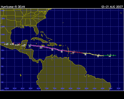
Dean
I'm a little late on this, but I thought Tropical Depression 4 would turn into Tropical Storm Dean so I waited. Dean is the first classic African wave storm to develop It certainly won't be the last.
Dean should reach hurricane strength in a day or two. The storm track will be interesting to see. Cuba could be impacted greatly.
Meanwhile TD #5 has popped up in the Gulf. Should just make tropical storm strength before hitting Texas.
NWS TPC/NATIONAL HURRICANE CENTER MIAMI FL AL042007
1100 PM AST TUE AUG 14 2007
...DEAN A LITTLE STRONGER...
INTERESTS IN THE LESSER ANTILLES SHOULD MONITOR THE PROGRESS OF
DEAN.
AT 1100 PM AST...0300Z...THE CENTER OF TROPICAL STORM DEAN WAS
LOCATED NEAR LATITUDE 12.0 NORTH...LONGITUDE 42.3 WEST OR ABOUT 1295
MILES...2085 KM...EAST OF THE LESSER ANTILLES.
DEAN IS MOVING TOWARD THE WEST NEAR 18 MPH...30 KM/HR...AND THIS
GENERAL MOTION IS EXPECTED TO CONTINUE DURING THE NEXT 24 HOURS.
MAXIMUM SUSTAINED WINDS ARE NEAR 50 MPH...85 KM/HR...WITH HIGHER
GUSTS. SOME STRENGTHENING IS FORECAST DURING THE NEXT 24 HOURS.
TROPICAL STORM FORCE WINDS EXTEND OUTWARD UP TO 50 MILES...85 KM
FROM THE CENTER.
ESTIMATED MINIMUM CENTRAL PRESSURE IS 1000 MB...29.53 INCHES.
Dean should reach hurricane strength in a day or two. The storm track will be interesting to see. Cuba could be impacted greatly.
Meanwhile TD #5 has popped up in the Gulf. Should just make tropical storm strength before hitting Texas.
Friday, August 10, 2007
Eastern Pacific Update
This is a report card on The Typhoon Times forecast for the Eastern Pacific hurricane season. To date we have had 9 total storms with two hurricanes (including Flossie which just became a minimal hurricane.)
I predicted 21 named storms in the Eastern Pacific with 8 of those storms becoming hurricanes.
Almost half-way there, and there is still quite some time to go.
I predicted 21 named storms in the Eastern Pacific with 8 of those storms becoming hurricanes.
Almost half-way there, and there is still quite some time to go.
Moving The Goalpost, Sort Of
Seem like the folks at the NOAA are getting a little antsy about the quiet Caribbean....but only a little: Forecasters: Fewer hurricanes for '07
Was this "revision" really necessary? If you forecast 17 tropical storms and 10 hurricanes in May, and we only get 16 and 9 isn't that still a successful forecast? I'd say damn successful.
I'm gonna stick to my prediction (made in April) of 19 and 8. To change now would be a little gutless.
Government forecasters minimally reduced their prediction for the Atlantic hurricane season Thursday, saying up to nine hurricanes and up to 16 tropical storms are expected to form.
The National Oceanic and Atmospheric Administration maintained its estimate that three to five of the hurricanes would be strong. The original report forecast up to 17 tropical storms, with up to 10 becoming hurricanes.
Federal forecasters' move Thursday follows that of Colorado State University hurricane researcher William Gray, who slightly lowered his forecast last week.
Gray's initial projection called for 17 named storms and nine hurricanes, five of them intense. He revised it to 15 named storms and eight hurricanes, four of them intense.
Was this "revision" really necessary? If you forecast 17 tropical storms and 10 hurricanes in May, and we only get 16 and 9 isn't that still a successful forecast? I'd say damn successful.
I'm gonna stick to my prediction (made in April) of 19 and 8. To change now would be a little gutless.
Thursday, August 2, 2007
TS Chantal (2007) In Historical Perspective
I decided to look at the other storms in the storm record that had a similar genesis point to tropical storm Chantal since 1930. It proves very interesting as it further reinforces the idea that serious undercounting of North Atlantic tropical storm in the pre-satellite era is endemic. I decided to look at all storms that had their genesis in the box bordered by the lines, 40 degrees north, 30 degrees north, 60 degrees west, and 70 degrees west (roughly this box brackets the island of Bermuda.) I've broken it down by decade below:
1930's:
1938, Tropical Storm #6, 40kts
1940's:
1942, Hurricane #3, 94kts
1942, Tropical Storm #5, 45kts
1942, Tropical Storm #6, 45kts
1943, Tropical Storm #7, 50kts
1950's:
1957, Hurricane Frieda, 70kts
1960's
1964, Tropical Storm, 45kts
1970's
1971, Hurricane #2, 70kts
1972, Hurricane Betty, 90kts
1973, Hurricane Fran, 70kts
1974, Subtropical #3, 45kts
1976, Hurricane Candice, 80kts
1980's
1981, Tropical Storm Bret, 60kts
1981, Tropical Storm Condy, 50kts
1983, Hurricane Chantal, 65kts
1984, Subtropical #1, 50kts
1984 Tropical Storm Cesar, 50 kts
1990's
1997, Hurricane Bill, 65kts
1998, Hurricane Karl, 90kts
2000's
2001, Hurricane Karen, 70kts
2003, Tropical Storm Ana, 45kts
2004, Tropical Storm Nicole, 45kts
2007, Tropical Storm Chantal, 45kts
Average number of storms per year in each decade:
Pre-satellite era
1930's: 0.1
1940's: 0.4
1950's: 0.1
1960's: 0.1
Satellite era:
1970's: 0.5
1980's: 0.6
1990's: 0.2
2000's: 0.5
For entire pre-satellite era 1930-1969: 0.175
For entire satellite era 1970-2007: 0.447
It should also be noted that four of the seven total storms found in the pre-satellite era were found at a time when the U.S. military had a submarine and air presence at Bermuda engaged in active wartime patrolling during the Second World War.
Tuesday, July 31, 2007
Chantal

VISIBLE SATELLITE IMAGES INDICATE THAT CHANTAL HAS STRENGTHENED THIS
MORNING WITH IMPRESSIVE CURVED BANDING ESPECIALLY IN THE NORTHERN
SEMICIRCLE. THE LOW-LEVEL CENTER OF THE STORM APPEARS TO BE
DISPLACED TO THE SOUTHEAST OF A CLEARLY IDENTIFIABLE MID-LEVEL
CENTER ON SATELLITE. A QUIKSCAT PASS JUST BEFORE 1000 UTC SHOWED
BELIEVABLE WIND VECTORS IN THE 40-45 KT RANGE AND THE INITIAL
INTENSITY WILL BE SET TO 45 KT. THE TROPICAL CYCLONE IS QUICKLY
MOVING INTO COOLER WATERS AND LITTLE ADDITIONAL INTENSIFICATION AS A
TROPICAL CYCLONE IS EXPECTED.
FORECAST POSITIONS AND MAX WINDS
INITIAL 31/1500Z 40.2N 62.7W 45 KT
12HR VT 01/0000Z 43.0N 59.7W 45 KT
24HR VT 01/1200Z 47.0N 52.7W 45 KT...EXTRATROPICAL
36HR VT 02/0000Z 51.2N 44.7W 50 KT...EXTRATROPICAL
48HR VT 02/1200Z 56.0N 36.0W 50 KT...EXTRATROPICAL
72HR VT 03/1200Z 60.0N 27.5W 50 KT...EXTRATROPICAL
96HR VT 04/1200Z 62.0N 20.0W 45 KT...EXTRATROPICAL
120HR VT 05/1200Z 64.5N 12.5W 40 KT...EXTRATROPICAL
It Is Worse Than Even *I* Thought
The Holland and Webster paper is now available and it is a doozy.
I've been having a discussion on another site with a true believer where the following exchange has taken place.
To which I responded:
I can't help but feel a sense of deja vu when I deal with this stuff. As I'm sitting here speculating about the natural mechanism that will cause more North Atlantic hurricanes to form while at the same time decreasing their landfalling incidence, I cannot help but think I've been here before.
And then it hit me. I wrote this back in September of 2005:
So, in order for these folks to hold onto their pet theory of AGW fueling increasing numbers of more intense hurricanes, they have to postulate a brand new mechanism that keep present day hurricanes from hitting, let's say, Florida, where hurricanes 50 years ago would have rudely barged right into it. We will keep the sheer ridiculous nature of the claim to one side for the moment. It must be admitted that these researchers are taking an approach to science that is positively Ptolemaic in its scope. Just like the followers of Ptolemey they pile complexity upon complexity in order to keep their vision afloat. As each new inconsistency is brought forward a new previously unknown mechanism is postulated as the "answer."
The end result is a hybrid monster of a theory which lacks for nothing but coherence and persuasiveness.
I've been having a discussion on another site with a true believer where the following exchange has taken place.
“While there are limitations to the data set, this is addressed in the article”
To which I responded:
No it isn’t. This is what the paper says:We use the ‘best track’ tropical cyclone database from the National Hurricane Center (Jarvinan et al. 1984). The only changes to the dataset data have been to include the intensity corrections recommended by Landsea (1993).
Then when they get to addressing Landsea’s contention about undercounting of Mid-Atlantic storms they say the following:Our conclusion is that the number of earlier missed storms most likely lies between 1 and 3 per year prior to 1900, less than 2 in the early nineteenth century and dropping off to essentially zero by 1960. The conclusion by Landsea (2007) of much higher numbers of missing storms is considered to be based on a false premise of an assumed constancy of landfalling storms ratio (Mann et al. submitted a,b; Holland in press).
So they “refute” the contention by referring to non-published material (some of it written BY THEMSELVES) that no one can check in any way shape or form. (Although you will notice, even though they claim they accept some problems in the data set they do not alter it an iota. The undercounting is ignored by their data set even after they acknowledge it.)
How is that acceptable? How did you find that convincing since you had no way of checking it at all?
(Although I’m intrigued at what this new and hitherto never discovered mechanism that makes current hurricanes LESS likely to strike land compared to storms in the past will prove to be. I think they might start having an Ockham’s Razor problem soon.)
I can't help but feel a sense of deja vu when I deal with this stuff. As I'm sitting here speculating about the natural mechanism that will cause more North Atlantic hurricanes to form while at the same time decreasing their landfalling incidence, I cannot help but think I've been here before.
And then it hit me. I wrote this back in September of 2005:
This brings me to the point of postulating unknown forces to back up your theory. A good rule of thumb is never subscribe to any theory that relies on such a rhetorical device.
So, in order for these folks to hold onto their pet theory of AGW fueling increasing numbers of more intense hurricanes, they have to postulate a brand new mechanism that keep present day hurricanes from hitting, let's say, Florida, where hurricanes 50 years ago would have rudely barged right into it. We will keep the sheer ridiculous nature of the claim to one side for the moment. It must be admitted that these researchers are taking an approach to science that is positively Ptolemaic in its scope. Just like the followers of Ptolemey they pile complexity upon complexity in order to keep their vision afloat. As each new inconsistency is brought forward a new previously unknown mechanism is postulated as the "answer."
The end result is a hybrid monster of a theory which lacks for nothing but coherence and persuasiveness.
Sunday, July 29, 2007
More BS Is Brewing
You can always tell when folks are selling bullshit as science because they feel the need to run everything like a public relations campaign. Which begs the question: What kind of snake oil are they selling?
First the story from Reuters: Study blames climate change for hurricanes
Of course, maybe they came up with something actually new and they did not (as I suspect) repackage the same old tired garbage that the media loves to print so much. And hey! The Reuters article said it was published online. I've looked for an hour and I cannot find it. If the article is available on the web why wouldn't Reuters have a link to it? Oh, that is because it hasn't actually been published yet. That happens tomorrow.
So what source of information is this "free and independent journalist" writing from?
Oh, I found that most important piece of present day "science"...the press release. Plus it's handy helper, the guide for idiot journalists. (So you can hold their hands when you tell them what to print.) But the actual study itself? Who needs it?!. Ah science.
Of course there is a name for all of this behavior. It is called "stealing a march." By placing sympathetic (with emphasis on the pathetic) stories in the media before anyone else can gainsay the report by doing crazy things like actually reading and studying it, you can get the message you want out in the press. And if it generates a few more press clippings that you can append to your next grant proposal, well who's to say anything against it?? That your actual work may be not worth the paper it is printed on is beside the point. You have what you want: another line on the CV, another hysterical item in the press, and another restful night because you know you will get your version of the story out and never have to deal with criticism from the other side until its too late.
It is bullshit, and unethical bullshit to boot.
First the story from Reuters: Study blames climate change for hurricanes
The number of Atlantic hurricanes in an average season has doubled in the last century due in part to warmer seas and changing wind patterns caused by global warming, according to a study released on Sunday.Gee, I'd like to see a study that can do that despite all the myriad problems with comparing satellite collected data from the space age with the spotty reports of the early 20th century. (See my take here, Chris Landsea's that I blogged about here.) Not to mention that the study seemingly contradicts the latest findings in the field which predict warming decreasing the number and intensities of tropical storms. (Blogged about here.)
Hurricane researchers have debated for years whether climate change caused by greenhouse gases from cars, factories and other human activity is resulting in more, and more intense, tropical storms and hurricanes.
The new study, published online in Philosophical Transactions of the Royal Society of London, said the increased numbers of tropical storms and hurricanes in the last 100 years is closely related to a 1.3-degree Fahrenheit rise in sea surface temperatures.
The influential U.N. Intergovernmental Panel on Climate Change, in a report this year warning that humans contribute to global warming, said it was "more likely than not" that people also contribute to a trend of increasingly intense hurricanes.
In the new study, conducted by Greg Holland of the National Center for Atmospheric Research and Peter Webster of Georgia Institute of Technology, researchers found three periods since 1900 when the average number of Atlantic tropical storms and hurricanes increased sharply, and then leveled off and remained steady.
From 1900 to 1930, Atlantic hurricane seasons saw six storms on average, with four hurricanes and two tropical storms. From 1930 to 1940, the annual average rose to ten, including five hurricanes.
Of course, maybe they came up with something actually new and they did not (as I suspect) repackage the same old tired garbage that the media loves to print so much. And hey! The Reuters article said it was published online. I've looked for an hour and I cannot find it. If the article is available on the web why wouldn't Reuters have a link to it? Oh, that is because it hasn't actually been published yet. That happens tomorrow.
So what source of information is this "free and independent journalist" writing from?
Oh, I found that most important piece of present day "science"...the press release. Plus it's handy helper, the guide for idiot journalists. (So you can hold their hands when you tell them what to print.) But the actual study itself? Who needs it?!. Ah science.
Of course there is a name for all of this behavior. It is called "stealing a march." By placing sympathetic (with emphasis on the pathetic) stories in the media before anyone else can gainsay the report by doing crazy things like actually reading and studying it, you can get the message you want out in the press. And if it generates a few more press clippings that you can append to your next grant proposal, well who's to say anything against it?? That your actual work may be not worth the paper it is printed on is beside the point. You have what you want: another line on the CV, another hysterical item in the press, and another restful night because you know you will get your version of the story out and never have to deal with criticism from the other side until its too late.
It is bullshit, and unethical bullshit to boot.
Thursday, July 12, 2007
Unisys Hurricane Data
The folks who maintain the mirror of the hurricane database over at Unisys are doing a nice job updating their site, this includes adding detailed notes and radar and satellite images for storms that impacted the United States. They are making an already good resource better.
They earn a Typhoon Times Hat Tip!
They earn a Typhoon Times Hat Tip!
Sunday, July 8, 2007
Tropical Storm 04W (Western Pacific)

1. TROPICAL STORM 04W (MAN-YI) WARNING NR 006
01 ACTIVE TROPICAL CYCLONE IN NORTHWESTPAC
MAX SUSTAINED WINDS BASED ON ONE-MINUTE AVERAGE
---
WARNING POSITION:
081800Z --- NEAR 8.4N 144.0E
MOVEMENT PAST SIX HOURS - 285 DEGREES AT 12 KTS
POSITION ACCURATE TO WITHIN 060 NM
POSITION BASED ON CENTER LOCATED BY SATELLITE
PRESENT WIND DISTRIBUTION:
MAX SUSTAINED WINDS - 035 KT, GUSTS 045 KT
WIND RADII VALID OVER OPEN WATER ONLY
REPEAT POSIT: 8.4N 144.0E
---
FORECASTS:
12 HRS, VALID AT:
090600Z --- 9.9N 142.2E
MAX SUSTAINED WINDS - 045 KT, GUSTS 055 KT
WIND RADII VALID OVER OPEN WATER ONLY
RADIUS OF 034 KT WINDS - 070 NM NORTHEAST QUADRANT
060 NM SOUTHEAST QUADRANT
060 NM SOUTHWEST QUADRANT
070 NM NORTHWEST QUADRANT
VECTOR TO 24 HR POSIT: 310 DEG/ 11 KTS
---
24 HRS, VALID AT:
091800Z --- 11.2N 140.5E
MAX SUSTAINED WINDS - 055 KT, GUSTS 070 KT
WIND RADII VALID OVER OPEN WATER ONLY
RADIUS OF 050 KT WINDS - 030 NM NORTHEAST QUADRANT
030 NM SOUTHEAST QUADRANT
030 NM SOUTHWEST QUADRANT
030 NM NORTHWEST QUADRANT
RADIUS OF 034 KT WINDS - 090 NM NORTHEAST QUADRANT
070 NM SOUTHEAST QUADRANT
070 NM SOUTHWEST QUADRANT
090 NM NORTHWEST QUADRANT
VECTOR TO 36 HR POSIT: 310 DEG/ 11 KTS
---
36 HRS, VALID AT:
100600Z --- 12.6N 138.9E
MAX SUSTAINED WINDS - 070 KT, GUSTS 085 KT
WIND RADII VALID OVER OPEN WATER ONLY
RADIUS OF 064 KT WINDS - 025 NM NORTHEAST QUADRANT
025 NM SOUTHEAST QUADRANT
025 NM SOUTHWEST QUADRANT
025 NM NORTHWEST QUADRANT
RADIUS OF 050 KT WINDS - 040 NM NORTHEAST QUADRANT
040 NM SOUTHEAST QUADRANT
040 NM SOUTHWEST QUADRANT
040 NM NORTHWEST QUADRANT
RADIUS OF 034 KT WINDS - 120 NM NORTHEAST QUADRANT
095 NM SOUTHEAST QUADRANT
095 NM SOUTHWEST QUADRANT
120 NM NORTHWEST QUADRANT
VECTOR TO 48 HR POSIT: 305 DEG/ 13 KTS
Thursday, July 5, 2007
Tropical Storm 03W (Western Pacific)
Missed this one over the holiday. Now a tropical depression as it has hit Vietnam.
051500Z POSITION NEAR 21.6N 107.0E.
TROPICAL DEPRESSION (TD) 03W (TORAJI) LOCATED APPROXIMATELY 85 NM
EAST-NORTHEAST OF HANOI, VIETNAM HAS TRACKED WEST-NORTHWESTWARD
AT 09 KNOTS OVER THE PAST SIX HOURS. THE SYSTEM HAS MADE LANDFALL
IN NORTHEASTERN VIETNAM AND IS FORECAST TO CONTINUE TO TRACK INLAND.
CURRENT INTENSITY IS BASED ON RECENT DVORAK ESTIMATES RANGING FROM
25 TO 35 KNOTS. THE STORM WILL CONTINUE TO WEAKEN AS IT TRACKS TO
THE NORTHWEST OVER LAND AND WILL DISSIPATE BEFORE TAU 24. THIS IS
THE FINAL WARNING ON THIS SYSTEM BY THE JOINT TYPHOON WARNING
CENTER (NAVPACMETOCCEN). THE SYSTEM WILL BE CLOSELY MONITORED FOR
SIGNS OF REGENERATION.
Friday, June 29, 2007

Thursday, June 21, 2007

Tuesday, June 5, 2007
Watching Water Warm


I know it looks like the water was warmer in April (the top image), but look at the scale under each map. It changes.
Tropical Cyclone Gonu
Here is an unusual one as a tropical cyclone threatens Oman and Iran:

050900Z POSITION NEAR 21.5N 61.6E.
TROPICAL CYCLONE (TC) 02A (GONU), LOCATED APPROXIMATELY 230 NM SOUTH-
EAST OF MUSCAT, OMAN, HAS TRACKED NORTHWESTWARD AT 07 KNOTS OVER THE
PAST 06 HOURS. ANIMATED MULTISPECTRAL SATELLITE IMAGERY INDICATES
THAT TC 02A HAS CONTINUED TO WEAKEN AT A LESS THAN CLIMATOLOGIC RATE
OVER THE PAST 06 HOURS. CURRENT INTENSITY IS BASED ON DVORAK
ESTIMATES OF 115 KNOTS ADJUSTED SLIGHTLY HIGHER DUE TO THE PRESENCE
OF A SMALL RAGGED EYE. TC 02A CONTINUES TO TRACK ALONG THE SOUTH-
WESTERN PERIPHERY OF THE SUBTROPICAL RIDGE ANCHORED OVER CENTRAL
INDIA. ANIMATED WATER VAPOR IMAGERY CONTINUES TO SHOW RELATIVELY
ZONAL FLOW OVER SOUTHWEST ASIA WITH A SERIES OF SHORTWAVE TROUGHS
EMBEDDED IN THE FLOW. A MIDLATITUDE TROUGH OVER THE MEDITERRANEAN SEA
CONTINUES TO PROPAGATE EASTWARD AND WILL WEAKEN THE SUBTROPICAL RIDGE
NEAR TAU 24, ENHANCING THE POLEWARD TURN OF THE SYSTEM. TC 02A IS
FORECAST TO MAKE LANDFALL IN SOUTHEASTERN IRAN AFTER TAU 36.
Saturday, June 2, 2007
Tropical Depression Barry
SATELLITE IMAGERY...RADAR...SURFACE DATA AND INFORMATION FROM AN AIR
FORCE RECONNAISSANCE PLANE INDICATE THAT THE CENTER OF BARRY HAS
BECOME ELONGATED AND HAS REACHED THE FLORIDA WEST COAST IN THE
VICINITY OF THE TAMPA BAY. THE WINDS NEAR THE CENTER HAVE DIMINISHED
TO BELOW TROPICAL STORM STRENGTH AND THE CYCLONE HAS BEEN
DOWNGRADED TO TROPICAL DEPRESSION STATUS. BARRY IS EXPECTED TO
BECOME FULLY EXTRATROPICAL LATER TODAY AFTER CROSSING FLORIDA GIVEN
THE CURRENT STRUCTURE AND THE WIND SHEAR. THE EXTRATROPICAL
TRANSFORMATION HAS BEEN SUGGESTED BY MOST OF THE GLOBAL MODELS.
THE EXTRATROPICAL LOW SHOULD INTENSITY AND IS FORECAST TO PRODUCE
GALE FORCE WINDS ALONG THE EAST COAST OF THE UNITED STATES.
Friday, June 1, 2007
Barry

All of that unsettled weather in the Gulf resulted in a tropical storm after all!
AT 5 PM EDT...2100 UTC... A TROPICAL STORM WARNING HAS BEEN ISSUED
FOR THE WEST COAST OF FLORIDA FROM BONITA BEACH NORTHWARD TO KEATON
BEACH...AND A TROPICAL STORM WATCH HAS BEEN ISSUED FROM NORTH OF
KEATON BEACH TO ST. MARKS. A TROPICAL STORM WARNING MEANS THAT
TROPICAL STORM CONDITIONS ARE EXPECTED WITHIN THE WARNING AREA
WITHIN THE NEXT 24 HOURS AND A TROPICAL STORM WATCH MEANS THAT
TROPICAL STORM CONDITIONS ARE POSSIBLE WITHIN THE WATCH
AREA...GENERALLY WITHIN 36 HOURS.
FOR STORM INFORMATION SPECIFIC TO YOUR AREA...INCLUDING POSSIBLE
INLAND WATCHES AND WARNINGS...PLEASE MONITOR PRODUCTS ISSUED
BY YOUR LOCAL WEATHER OFFICE.
AT 500 PM EDT...2100Z...THE CENTER OF TROPICAL STORM BARRY WAS
LOCATED NEAR LATITUDE 24.2 NORTH...LONGITUDE 85.5 WEST OR ABOUT 320
MILES...520 KM...SOUTHWEST OF TAMPA FLORIDA AND ABOUT 235 MILES...
375 KM...WEST OF KEY WEST FLORIDA.
BARRY IS MOVING TOWARD THE NORTH NEAR 12 MPH...19 KM/HR. A GRADUAL
TURN TO THE NORTH-NORTHEAST WITH AN INCREASE IN FORWARD SPEED IS
EXPECTED DURING THE NEXT 24 HOURS.
MAXIMUM SUSTAINED WINDS ARE NEAR 45 MPH...75 KM/HR...WITH HIGHER
GUSTS. NO SIGNIFICANT CHANGE IN STRENGTH IS ANTICIPATED BEFORE
BARRY REACHES THE COAST.
INITIAL 01/2100Z 24.2N 85.5W 40 KT
12HR VT 02/0600Z 26.5N 84.5W 40 KT
24HR VT 02/1800Z 30.0N 83.0W 45 KT
36HR VT 03/0600Z 33.0N 81.0W 30 KT...EXTRATROPICAL
48HR VT 03/1800Z 35.0N 78.0W 30 KT...EXTRATROPICAL
72HR VT 04/1800Z 41.0N 70.5W 30 KT...EXTRATROPICAL
96HR VT ABSORBED BY FRONTAL SYSTEM
Florida is in such severe rainfall defecit, a storm like Barry will be quite welcome.
Thursday, May 31, 2007
Barbara
It looks likely that Barbara will NOT be the first eastern pacific hurricane of the season:
This just underscores how quickly these storm models can fall apart.
QUIKSCAT DATA FROM THIS MORNING SHOWED THAT BARBARA HAS...AT
BEST...A VERY SMALL CIRCULATION EMBEDDED WITHIN A LARGER SCALE
TROUGH. CONVECTION ASSOCIATED WITH THE CIRCULATION REMAINS ACTIVE
BUT POORLY ORGANIZED. THE CYCLONE IS COMPETING FOR RESOURCES
WITHIN A BROAD AREA OF DISTURBED WEATHER...AND COULD DISSIPATE
WITHIN THIS ZONE AT ANY TIME. HOWEVER...GLOBAL MODELS SUGGEST THAT
THE EASTERLY SHEAR CURRENTLY AFFECTING THE CYCLONE COULD ABATE OVER
THE NEXT COUPLE OF DAYS...SO THE OFFICIAL FORECAST WILL CONTINUE TO
SHOW MODEST STRENGTHENING IN LINE WITH THE GFDL AND SHIPS GUIDANCE.
INITIAL 31/2100Z 12.9N 95.5W 35 KT
12HR VT 01/0600Z 12.9N 95.0W 35 KT
24HR VT 01/1800Z 13.3N 94.6W 40 KT
36HR VT 02/0600Z 14.0N 94.4W 45 KT
48HR VT 02/1800Z 15.0N 94.5W 50 KT
72HR VT 03/1800Z 15.5N 95.0W 50 KT
96HR VT 04/1800Z 16.0N 95.5W 40 KT...INLAND
120HR VT 05/1800Z 16.5N 96.0W 25 KT...INLAND
This just underscores how quickly these storm models can fall apart.
2007 Atlantic & Eastern Pacific Forecast (May 31st)
Here is the final Typhoon Times forecast for the 2007 Hurricane season in the Atlantic and Eastern Pacific.
Atlantic:
Named Storms: 19
Hurricanes: 8
Eastern Pacific:
Named Storms: 21
Hurricanes: 8
This forecast is the same as the Typhoon Times' early April prediction.
While the forecast will no longer be revised, as it makes no sense to change the "forecast" for the season while said season is on-going, we will be doing monthly round-ups to measure how the forecast is fairing.
We will also compare it to other forecasts for the season, such as the one furnished by Colorado State (which was also unchanged from their April forecast):
The Colorado State University hurricane research team renewed its forecast for an "above average" 2007 Atlantic storm season on Thursday and predicted 17 tropical storms, with nine growing to hurricane strength.
Wednesday, May 30, 2007
Eastern Pacific: Alvin and Barbara

On Alvin:
TROPICAL DEPRESSION CENTER LOCATED NEAR 13.4N 114.6W AT 30/1500Z
POSITION ACCURATE WITHIN 30 NM
PRESENT MOVEMENT TOWARD THE WEST-NORTHWEST OR 300 DEGREES AT 3 KT
ESTIMATED MINIMUM CENTRAL PRESSURE 1005 MB
MAX SUSTAINED WINDS 30 KT WITH GUSTS TO 40 KT.
WINDS AND SEAS VARY GREATLY IN EACH QUADRANT. RADII IN NAUTICAL
MILES ARE THE LARGEST RADII EXPECTED ANYWHERE IN THAT QUADRANT.
REPEAT...CENTER LOCATED NEAR 13.4N 114.6W AT 30/1500Z
AT 30/1200Z CENTER WAS LOCATED NEAR 13.3N 114.5W
FORECAST VALID 31/0000Z 13.6N 115.1W
MAX WIND 30 KT...GUSTS 40 KT.
On Barbara:
THE TROPICAL CYCLONE REMAINS NEARLY STATIONARY. WATER VAPOR IMAGERY
INDICATES THAT A LARGE MID- TO UPPER-LEVEL TROUGH IS DEVELOPING OVER
MEXICO AND THE WESTERN GULF OF MEXICO...WITH A LARGE MID/UPPER-
LEVEL RIDGE OVER THE PACIFIC WEST OF THE TROUGH. THE IMAGERY ALSO
SHOWS MID-LEVEL NORTHERLIES ABOUT TO IMPINGE ON THE CIRCULATION.
IN THE SHORT TERM...THIS SHOULD RESULT IN A SOUTHWARD DRIFT AWAY
FROM THE MEXICAN COASTLINE...AND MODEL GUIDANCE IS IN GOOD
AGREEMENT ON THIS FOR THE FIRST DAY OR TWO OF THE FORECAST. AFTER
THAT...HOWEVER...THERE IS A GREAT DEAL OF UNCERTAINTY AS TO WHETHER
BARBARA WILL BE STEERED NORTHEASTWARD AHEAD OF THE GULF TROUGH OR
SLIDE WESTWARD AS THE TROUGH LIFTS OUT AND RIDGING BUILDS BEHIND
IT. IN THE FORMER CAMP ARE THE GFS AND ECMWF...WHILE A MORE
WESTWARD TRACK IS INDICATED BY THE GFDL...UKMET...AND NOGAPS.
INTERESTINGLY...THE ECMWF ENSEMBLES ARE PRETTY MUCH SPLIT BETWEEN
THESE TWO OPTIONS. THE OFFICIAL FORECAST...ADMITTEDLY LOW
CONFIDENCE...CONTINUES TO FAVOR THE MORE WESTWARD SCENARIO.
THE INTENSITY FORECAST IS DIFFICULT AS WELL. THE MID-LEVEL
NORTHERLIES APPROACHING THE CYCLONE WILL ADVECT SOME DRY AIR INTO
THE CIRCULATION AND INCREASE THE VERTICAL SHEAR. CONSEQUENTLY...
BARBARA COULD STRUGGLE IN THE SHORT RUN. OVERALL...HOWEVER...
CONDITIONS APPEAR FAVORABLE FOR DEVELOPMENT...WITH VERY WARM WATERS
AND GOOD UPPER OUTFLOW.
FORECAST POSITIONS AND MAX WINDS
INITIAL 30/1500Z 14.2N 97.3W 35 KT
12HR VT 31/0000Z 13.9N 97.2W 35 KT
24HR VT 31/1200Z 13.4N 97.1W 40 KT
36HR VT 01/0000Z 13.0N 97.0W 50 KT
48HR VT 01/1200Z 13.0N 96.8W 60 KT
72HR VT 02/1200Z 13.5N 96.5W 70 KT
96HR VT 03/1200Z 15.0N 97.5W 75 KT
120HR VT 04/1200Z 16.5N 100.0W 70 KT
Barbara should be the more interesting to watch. We shall see how well the forecast predicts this storm, as they think it will be a Cat 1 hurricane on June 2nd.
Thursday, May 24, 2007
Substituting Dogma For Science Is A Really Bad Idea: Example #447
From Reuters (via CNN): Study: Killer hurricanes thrived in cooler seas
This simply underscores how the claims of the IPCC on hurricanes were in no way based upon the actual state of the scientific evidence. To claim the IPCC report represent the "consensus" of scientific opinion is so far from the truth it isn't even worthy of dicsussion.
The sad fact is the politicians of the IPCC needed to make these sorts of false hurricane claims to bolster their political contentions that the world was in mortal danger. It was a scare tactic, and a knowingly cynical one at that.
I'm not particularly surprised at these findings. Look at the picture of a cyclonic storm below:

This is a picture of what is known as a "polar low." This photograph is of a storm just off of the coast of Iceland. Polar lows don't just look like tropical hurricanes, they have been known to reach hurricane force winds as well. These storms take place in the coldest waters on earth, so it has always seemed obvious that the warmth of the waters couldn't have been the determining factor on the development of cyclonic storms generally speaking.
So the IPCC is not selling science when they speak of hurricanes, they are selling a morality tale. "See the big bad people make the water warmer by their greed. See the warm water create hurricanes. See the hurricanes destroy the big bad greedy people."
One might think that some media members might catch on to this overwhelmingly simplistic reasoning about such a massively complex scientific problem as hurricane genesis.
Unfortunately, the media loves a good morality tale more than they love science.
Cross Posted at The Iconic Midwest
Hurricanes over the past 5,000 years appear to have been controlled more by El Nino and an African monsoon than warm sea surface temperatures, such as those caused by global warming, researchers said Wednesday.
The study, published in the journal Nature, adds to the debate on whether seas warmed by greenhouse gas emissions lead to more hurricanes, such as those that bashed the Gulf of Mexico in 2005.
Some researchers say warmer seas appear to have contributed to more intense hurricanes, while others disagree. The U.N. International Panel on Climate Change said this year it was more likely than not that humans contribute to a trend of increasingly intense hurricanes.[emphasis added]
This simply underscores how the claims of the IPCC on hurricanes were in no way based upon the actual state of the scientific evidence. To claim the IPCC report represent the "consensus" of scientific opinion is so far from the truth it isn't even worthy of dicsussion.
The sad fact is the politicians of the IPCC needed to make these sorts of false hurricane claims to bolster their political contentions that the world was in mortal danger. It was a scare tactic, and a knowingly cynical one at that.
Frequent strong hurricanes thrived in the Western Atlantic during times of weak El Ninos, or warming of surface waters of the Eastern Pacific Ocean, and strong West African monsoons even when local seas were cooler than now, the study said.
"Tropical sea surface temperatures as warm as at present are apparently not a requisite condition for increased intense hurricane activity," Jeffrey Donnelly, the lead author and researcher at the Woods Hole Oceanographic Institution, said in the study.
Intense hurricanes made landfall during the latter half of the Little Ice Age, a period of cooling that occurred approximately from the 14th to mid-19th centuries, he said.
...
Intense hurricanes hit when local sea surface temperatures were warm or cool. In fact, "the Caribbean experienced a relatively active interval of intense hurricanes for more than a millennium when local sea surface temperatures were on average cooler than modern," the study said.
I'm not particularly surprised at these findings. Look at the picture of a cyclonic storm below:

This is a picture of what is known as a "polar low." This photograph is of a storm just off of the coast of Iceland. Polar lows don't just look like tropical hurricanes, they have been known to reach hurricane force winds as well. These storms take place in the coldest waters on earth, so it has always seemed obvious that the warmth of the waters couldn't have been the determining factor on the development of cyclonic storms generally speaking.
So the IPCC is not selling science when they speak of hurricanes, they are selling a morality tale. "See the big bad people make the water warmer by their greed. See the warm water create hurricanes. See the hurricanes destroy the big bad greedy people."
One might think that some media members might catch on to this overwhelmingly simplistic reasoning about such a massively complex scientific problem as hurricane genesis.
Unfortunately, the media loves a good morality tale more than they love science.
Cross Posted at The Iconic Midwest
Tuesday, May 22, 2007
More Hurricane Alarmism
I sort of wish the media would stop covering these stories since they seem incapable of understanding them correctly: Experts predict 'active' hurricane season
OK, lets look at this. Since 1967 the percentage of tropical storms that have made landfall in Florida is a little over 13%. On average, also from 1967, 1.45 tropical storms make landfall in Florida every year. Since storms hit in full integers lets say, one or two a year.
Now, given the range of 13 to 17 tropical storms predicted, we would expect Florida landfalls in the 1.69 to 2.21 range, or one to three this year.
Sure it could be more or it could be less, but if you are in the media you are probably better off giving people an idea of what they can expect on average. Presenting it as if Floridians are facing a 400% greater risk is simply fear mongering.
Plus, the claim is simply false. For example, Florida has been hit by at least one tropical system in 16 of the last 17 hurricane seasons (or 94%). Given such a track record, saying that in this year they are 4 times as likely to be hit is simple nonsense.
Story Highlights• Forecasters predict seven to 10 hurricanes this season
• Expert: Florida 4 times as likely to be hit, Texas twice as likely
• El Nino over, making way for more storms on East, Gulf coasts
• Last year, there were 10 named storms in the Atlantic
...
Government forecasters called for a busier than normal hurricane season Tuesday.
National Weather Service forecasters said they expect 13 to 17 tropical storms, with seven to 10 of them becoming hurricanes.
OK, lets look at this. Since 1967 the percentage of tropical storms that have made landfall in Florida is a little over 13%. On average, also from 1967, 1.45 tropical storms make landfall in Florida every year. Since storms hit in full integers lets say, one or two a year.
Now, given the range of 13 to 17 tropical storms predicted, we would expect Florida landfalls in the 1.69 to 2.21 range, or one to three this year.
Sure it could be more or it could be less, but if you are in the media you are probably better off giving people an idea of what they can expect on average. Presenting it as if Floridians are facing a 400% greater risk is simply fear mongering.
Plus, the claim is simply false. For example, Florida has been hit by at least one tropical system in 16 of the last 17 hurricane seasons (or 94%). Given such a track record, saying that in this year they are 4 times as likely to be hit is simple nonsense.
Saturday, May 12, 2007
Bitching In Unexpected Places?
Maybe I'm reading too much into this, but I found this interesting. From a statement from the National Hurricane Center:
Now, I read a lot of these statements and little asides are not exactly unknown, but there is something being implied here. It just sounds like there may be a squabble over money.
Cross posted at The Iconic Midwest.
SPECIAL TROPICAL DISTURBANCE STATEMENT
NWS TPC/NATIONAL HURRICANE CENTER MIAMI FL
1135 AM EDT SAT MAY 12 2007
A BROAD AREA OF LOW PRESSURE...THE REMNANT OF SUBTROPICAL STORM
ANDREA...IS CENTERED ABOUT 170 MILES EAST OF DAYTONA BEACH FLORIDA.
SATELLITE IMAGERY AND SURFACE OBSERVATIONS INDICATE THE SYSTEM HAS
BECOME BETTER ORGANIZED...AND IT COULD BECOME A TROPICAL DEPRESSION
DURING THE NEXT 24 HOURS AS IT MOVES SLOWLY TOWARD THE NORTHEAST.
AN AIR FORCE RESERVE RECONNAISSANCE MISSION THAT WAS SCHEDULED FOR THIS AFTERNOON HAS BEEN CANCELED DUE TO RESOURCE ISSUES.
Now, I read a lot of these statements and little asides are not exactly unknown, but there is something being implied here. It just sounds like there may be a squabble over money.
Cross posted at The Iconic Midwest.
Thursday, May 10, 2007
Andrea, We Hardly Knew Ye
And that pretty much is the end of Andrea. It is too bad as Florida could have used the rainfall.
SUBTROPICAL DEPRESSION ANDREA DISCUSSION NUMBER 5
NWS TPC/NATIONAL HURRICANE CENTER MIAMI FL AL012007
1100 AM EDT THU MAY 10 2007
DEEP CONVECTION IS DISAPPEARING QUICKLY AND ONLY A FEW THUNDERSTORMS
REMAIN IN THE NORTHEASTERN QUADRANT. IT IS THEREFORE NO SURPRISE
THAT THE STRONGEST FLIGHT-LEVEL WINDS MEASURED AT 1000 FT BY THE
AIR FORCE RECONNAISSANCE AIRCRAFT THIS MORNING WERE LESS THAN 40
KT. ANDREA IS DOWNGRADED TO A SUBTROPICAL DEPRESSION WITH 30 KT
MAXIMUM WINDS. A COMEBACK SEEMS UNLIKELY IN THE DRY AND STABLE
ENVIRONMENT
Wednesday, May 9, 2007
Early Season Storms Since 1967
Andrea is the ninth storm since 1967 to have an origin date earlier than June 1st.
The others:
1970: Hurricane Alma (70 knots)
1972: Subtropical Storm Alpha (40 knots)
1976: Subtropical Storm 1 (45 knots)
1978: Subtropical Storm 1 (40 knots)
1981: Tropical Storm Arlene (50 knots)
1992: Subtropical Storm 1 (45 knots)
1997: Subtropical Strom 54 (45 knots)
2003: Tropical Storm Ana (50 knots)
Sub-Tropical Storm Andrea

Say "Hello" to Andrea:
SATELLITE IMAGERY AND AIRCRAFT DATA INDICATE THAT THE LOW PRESSURE
SYSTEM OFF THE SOUTHEAST U.S. COAST HAS ACQUIRED SUBTROPICAL
CHARACTERISTICS.
AT 11 AM EDT...1500 UTC...A TROPICAL STORM WATCH HAS BEEN ISSUED
ALONG THE SOUTHEAST COAST OF THE UNITED STATES FROM ALTAMAHA SOUND
GEORGIA SOUTHWARD TO FLAGLER BEACH FLORIDA. A TROPICAL STORM WATCH
MEANS THAT TROPICAL STORM CONDITIONS ARE POSSIBLE WITHIN THE WATCH
AREA...GENERALLY WITHIN THE NEXT 36 HOURS.
...
ANDREA IS MOVING GENERALLY TOWARD THE WEST NEAR 3 MPH. A CONTINUED
SLOW MOTION AND A GRADUAL TURN TOWARD THE SOUTHWEST ARE EXPECTED
DURING THE NEXT 24 HOURS. ALONG THIS TRACK...THE CENTER OF ANDREA
IS EXPECTED TO REMAIN OFFSHORE OF THE U.S. COAST THROUGH AT LEAST
THURSDAY MORNING.
MAXIMUM SUSTAINED WINDS ARE NEAR 45 MPH...75 KM/HR...WITH HIGHER
GUSTS. LITTLE CHANGE IN STRENGTH IS FORECAST DURING THE NEXT 24
HOURS.
WINDS OF 40 MPH EXTEND OUTWARD UP TO 115 MILES...185 KM...MAINLY TO
THE EAST OF THE CENTER.
THE LATEST MINIMUM CENTRAL PRESSURE REPORTED BY AN AIR FORCE RESERVE
RECONNAISSANCE AIRCRAFT WAS 1003 MB...29.62 INCHES.
SINCE THE HEAVIEST RAINS ASSOCIATED WITH ANDREA ARE EXPECTED TO
REMAIN OFFSHORE DURING THE NEXT 24 HOURS... ANDREA IS NOT EXPECTED
TO PRODUCE SIGNIFICANT RAINFALL OVER ANY LAND AREAS THROUGH AT
LEAST THURSDAY MORNING.
Tuesday, May 8, 2007
First Rumblings Of The Pre-Season
Starting off with a non-tropical disturbance kind of eases us into the flow of things: Atlantic SPECIAL TROPICAL DISTURBANCE STATEMENT
SPECIAL TROPICAL DISTURBANCE STATEMENT
NWS TPC/NATIONAL HURRICANE CENTER MIAMI FL
400 PM EDT TUE MAY 8 2007
A NON-TROPICAL LOW PRESSURE SYSTEM...CENTERED ABOUT 200 MILES
SOUTHEAST OF THE GEORGIA AND SOUTH CAROLINA COASTS...HAS BEEN
MOVING SLOWLY WESTWARD AT 5 TO 10 MPH. THE LOW IS PRODUCING
GALE-FORCE WINDS NEAR THE COASTS OF NORTH CAROLINA...SOUTH
CAROLINA...AND GEORGIA. THIS SYSTEM HAS CHANGED LITTLE SINCE THIS
MORNING...AND NO SIGNIFICANT STRENGTHENING IS EXPECTED. THE LOW IS
BEING MONITORED FOR SIGNS OF TROPICAL OR SUBTROPICAL CYCLONE
DEVELOPMENT...AND AN AIR FORCE RESERVE RECONNAISSANCE AIRCRAFT WILL
BE AVAILABLE TO INVESTIGATE THE SYSTEM TOMORROW MORNING...IF
NECESSARY.
INTERESTS ALONG THE COAST OF THE SOUTHEASTERN UNITED STATES SHOULD
MONITOR PRODUCTS ISSUED BY LOCAL NATIONAL WEATHER SERVICE FORECAST
OFFICES. ADDITIONAL INFORMATION ON THIS SYSTEM CAN ALSO BE FOUND
IN HIGH SEAS FORECASTS ISSUED BY THE NATIONAL WEATHER SERVICE...
UNDER AWIPS HEADER NFDHSFAT1 AND WMO HEADER FZNT01 KWBC.

Tuesday, April 10, 2007

A Bold Prediction
The folks at the Department of Atmospheric Science at Colorado State University have released their latest Hurricane Forecast for the Atlantic 2007 season. In it they are predicting 17 named storms with 9 becoming hurricanes. The fifty year average (1950-2000) is 9.6 and 5.9 respectively. Now I wouldn't use the numbers before satellite coverage of the entire Atlantic basin was achieved in the mid 1960's, but those number are good as a very general baseline. (You can read about my concerns on the validity of these numbers here. I will note that even in this age of saturation coverage of the Atlantic they STILL missed a storm this year in the initial reportage. They had originally said 9 tropical storms took place in the Atlantic but it has been revised to 10. So please don't carve these into marble just yet.)
I have decided that I too will be releasing a hurricane forecast this year. I will give prediction now, and a revised one right after the June 1st start of the hurricane season.
For the Atlantic basin I predict 19 named storms with 8 becoming hurricanes. Additionally, I predict 21 named storms in the Eastern Pacific with 8 of those storms becoming hurricanes.
The preceding prediction is really too specific and I would be surprised to see those number hit close to exact. Things are too variable from season to season for that level of specificity, but this is what a forecast is.
I am more interested to see how my number do in a more general sense. Combining the Eastern Pacific and Atlantic basins I am expecting 40 named storms with 16 hurricanes. I think I can hit this number pretty closely.
Only time will tell. If I am way wrong people can rip me seven ways from Sunday...but they gotta wait until next December.
Wednesday, March 28, 2007
I Predict The "Prediction" Won't Actually Predict Anything
Here is a non-stop laugh riot courtesy of Reuters: Strong hurricanes to hit U.S. Gulf in 07: AccuWeather
Not a prediction. The Gulf faces hurricane "threats" every single year.
Using this standard, I predict the sun will rise tomorrow, California will face earthquake "threats" this year, and the Arizona Cardinals have a chance for an undefeated season.
I am the god of prognostication.
Oh, we may not get the same number of storms this season we did in the most active season in at least 150 years? Way to go out on a limb there.
Using this standard, I predict that it may be difficult for Newt Gingrich to gather 65% of the vote in the 2008 Presidential election, and Yadier Molina just might not bat .400 this season.
The tea leaves speak to me.
An actual prediction! (Although not made by the folks the story is supposed to be about.) Yes, it is a prediction for an average season, as from 1995-2006 we have averaged 3.9 Cat 3 or higher storms per year.
Using this standard, I predict that male babies born in the US in 2007 will grow up to an average height of 5-10 to 5-11.
Tremble at the sight of my crystal ball.
Once again, not a prediction.
Using this standard, I predict that people walking around urban areas with hundred dollar bills falling out of their pockets will likely be the victim of crime eventually.
I am the eyes of Nostradamus. All your ways are known to me.
Cross posted at The Iconic Midwest
The U.S. Gulf Coast, which is still rebuilding almost two years after Hurricane Katrina, faces a renewed threat of powerful storms this year, private forecaster AccuWeather said on Tuesday.
Not a prediction. The Gulf faces hurricane "threats" every single year.
Using this standard, I predict the sun will rise tomorrow, California will face earthquake "threats" this year, and the Arizona Cardinals have a chance for an undefeated season.
I am the god of prognostication.
After a quiet hurricane season last year, Florida and other Gulf Coast states likely will be hit with fewer storms than during the active 2005 season, which spawned the massive hurricanes Katrina and Rita, AccuWeather said.
But the storms forecast for the region will pack a punch.
"We will not get anywhere near the amount of storms that we did in 2005, but the intensity of the storms we do get will be of major concern," Joe Bastardi, chief hurricane forecaster for AccuWeather.com, said in a statement.
Oh, we may not get the same number of storms this season we did in the most active season in at least 150 years? Way to go out on a limb there.
Using this standard, I predict that it may be difficult for Newt Gingrich to gather 65% of the vote in the 2008 Presidential election, and Yadier Molina just might not bat .400 this season.
The tea leaves speak to me.
British forecasting group Tropical Storm Risk this month also predicted an active storm season. It forecast four "intense" hurricanes during the 2007 season, which runs from June through November.
An actual prediction! (Although not made by the folks the story is supposed to be about.) Yes, it is a prediction for an average season, as from 1995-2006 we have averaged 3.9 Cat 3 or higher storms per year.
Using this standard, I predict that male babies born in the US in 2007 will grow up to an average height of 5-10 to 5-11.
Tremble at the sight of my crystal ball.
Bastardi also predicted the U.S. Northeast would likely be a target for strong storms for the next 10 years.
Once again, not a prediction.
Using this standard, I predict that people walking around urban areas with hundred dollar bills falling out of their pockets will likely be the victim of crime eventually.
I am the eyes of Nostradamus. All your ways are known to me.
Cross posted at The Iconic Midwest
Saturday, February 10, 2007
Tropical Cyclone Enok

102100Z POSITION NEAR 20.1S 64.2E.
TROPICAL CYCLONE (TC) 13S (ENOK), LOCATED APPROXIMATELY 460 NM EAST-
NORTHEAST OF LA REUNION, HAS TRACKED SOUTHEASTWARD AT 19 KNOTS OVER
THE PAST SIX HOURS. TC 13S CONTINUES TO TRACK RAPIDLY SOUTHEASTWARD
IN THE STRONG GRADIENT BETWEEN RIDGING TO THE NORTHEAST AND TROUGHING
ASSOCIATED WITH THE REMNANTS OF TC 10S TO THE SOUTHWEST. THIS MOTION
IS EXPECTED TO CONTINUE THROUGH THE FORECAST PERIOD, WITH SOME REDUC-
TION IN FORWARD SPEED AS THE REMNANT LOW OF 10S FILLS AND ASSOCIATED
TROUGHING DISSIPATES. THE STORM IS EXPECTED TO WEAKEN VERY SLOWLY
OVER THE NEXT 48 HOURS AS FAVORABLE EQUATORWARD OUTFLOW AND ENHANCED
POLEWARD OUTFLOW ASSOCIATED WITH A DEVELOPING UPPER LEVEL LOW TO THE
SOUTH OF THE STORM WORK TO OFFSET THE NEGATIVE IMPACTS OF DECREASING
SEA SURFACE TEMPERATURES AND DRY AIR ENTRAINMENT. THE STORM IS EXPEC-
TED TO BEGIN EXTRATROPICAL TRANSITION BETWEEN TAU 36 AND TAU 48 DUE
TO INCREASING INTERACTION WITH THE MID-LATITUDE FLOW PATTERN TO THE
SOUTH. MAXIMUM SIGNIFICANT WAVE HEIGHT AT 101800Z IS 15 FEET.
Wednesday, February 7, 2007
Undercounting of Mid-Atlantic Tropical Storms
It is common to see claims that the incidences of tropical storms in the Atlantic basin are accounted for in the relevant database. For example, Kerry Emanuel has stated, "Tropical cyclone detection rates have been close to 100% globally since around 1970, when global satellite coverage became nearly complete 1. In densely travelled oceans, such as the North Atlantic, detection rates were probably reasonably high well back into the 19th century."
Certainly, since the mid-1960's when satellite coverage of the basin began, every tropical storm has been identified. However, in the period from 1900 until the mid-60's it is not so clear. This note will attempt to show that the evidence leans to the conclusion that the storm databases seriously undercounts storms that never leave the Mid-Atlantic.
A Definition:
For the purposes of this study the term "Mid-Atlantic Storm" is defined as any storm that remains east of the 60 degrees west line of longitude.

The 60 degrees west line was chosen because it is close to the chain of the Windward Islands, the first land masses a Mid-Atlantic storm could likely encounter. It also seems likely storms to the east or north-east of this line of islands which remained there, would be the most difficult to identify and, thus, the most likely to remain uncounted.
Data:
For the purposes of this study I am using the Tropical Prediction Center Best Track Reanalysis (archived here). Specifically, I will be looking at the data from 1907-2006. This somewhat arbitrary selection gives me an even 100 years worth of data to examine. However, it seems no more arbitrary than selecting another date, say 1900, as a starting point because it also is a nice round number. An advantage to the dates I've selected is that it will give me 10 equal decades with which to make comparisons. (Note: The data for the 2006 season is not part of the raw Hurricane Database file, but was included from the Tropical Prediction Center Advisories.)
Mid-Atlantic Tropical Storms:
I first examined the records to see just how many Mid-Atlantic tropical storms there have been indicated. Fig. 1 shows the storms averaged by decade from 1907-2006. (Click on any Fig. # to get a larger view of the graphs.)
 Fig. 1
It is obvious there is a vast difference in the numbers of storms we see in the database. The era from 1967 to 2006 sees over three times the numbers of Mid-Atlantic storms when compared to the previous six decades.
A similar story is seen if we look at the same numbers as averages of all tropical storms. (Fig. 2.)
 Fig. 2
From a low of 1.4% of all storms in the decade 1907-1916 (1 out of 70 total storms), Mid-Atlantic storms made up nearly 1/4 of all storms in the decade 1987-1996 (26 of 106 storms or 24.5%). One might claim these numbers represent the variability of storm incidence in the Atlantic basin, but it seems unlikely when you consider that the range can vary 30 fold. There was one (1) recorded Mid-Atlantic storm from 1907-1916 and 31 recorded for the time period of 1997-2006.
It is my contention that a good part of the difference in Mid-Atlantic storm numbers over time is due to the undercounting of Mid-Atlantic storm.
Hypothesis:
In order to test my contention that the discrepancies in the storm numbers are due more to undercounting as opposed to natural variability, I will look at storm numbers from the same time period that are not in contention. Namely, I will look at the incidences of U.S. landfalling storms and compare them to the numbers and rates we found in the Mid Atlantic tropical storms. If the differences are primarily due to natural variation in storm rates we would expect to find those rates duplicated in the landfalling storms. Conversely, if my contention is correct and there has been undercounting of storms we should find, at least, that the ratio of U.S. landfalling storms (or any subset thereof) to all storms was higher in the past (due to inaccurate Mid-Atlantic storm counts), and that the ratio will decline once better storm detection techniques are in place.
In order to have multiple points for comparison I divided U.S. landfalls into two categories. The first consists of storm landfalls on the coast of Florida. The second consists of storm landfalls on the coasts of Louisiana, North Carolina and Texas inclusive. The two categories have roughly similar landfall rates to each other so it seemed like a good match. In reality, it shouldn't matter how I divide up U.S. landfalls (or even if I divide them) as we are looking for the rates of landfalls over time.
The next figure looks at the decadal average for land falling storms in Florida.
 Fig. 3
As can be seen, the decadal average of landfalling storms in Florida is nearly equal when comparing the satellite years (1967-2006, 14.50 storms per decade) and the pre-satellite years (1907-1966, 14.67 storms per decade.)
For Louisiana, North Carolina and Texas the numbers tell a similar story:
 Fig. 4
In this data the satellite years averaged 17.75 landfalling storms a decade, as opposed to 17.16 a decade for the pre-satellite years.
We do not find the large variation in numbers here that we found in the Mid Atlantic storms. This is suggestive of undercounting, but it could be argued that some closer examination of the data would find large known variations elsewhere in the Atlantic basin. This seems unlikely (to put it mildly.) In order to confirm that these results are probably due to undercounting, we need to compare the ratios of these landfalling storms to all storms in the basin. If other parts of the basin were experiencing more storms than we should find that the ratio of landfalling storms to all storms should be fairly constant over time. The data does not show that to be the case. (Figures 5 and 6)
 Fig. 5
 Fig. 6
As I consistently find that the ratio of land-falling storms to all storms is higher in the pre-satellite era, I am forced to conclude that the hypothesis is well founded. While I cannot say with 100% certainty that it is true, I am after all postulating large tropical storms for which there are no records, the basic logic of my approach seems inescapable.
Conclusion:
It seems very probable the Mid-Atlantic storm counts are undercounted in some fashion. It is a trickier question to determine the degree of undercounting. However, if we take the rates of Mid-Atlantic storms found during the satellite era (see Figure 2 above) and apply them to the pre-satellite era the results are startling. Broken down by decade, the percentage of Mid-Atlantic storms to all storms in the satellite era looks like:
1967-1976: 17.20%
1977-1986: 14.44%
1987-1996: 24.53%
1997-2006: 21.23%
and for the entire period:
1967-2006: 19.77%
If we look at the minimum (14.44%) and maximum (24.53%) values as defining a range for the pre-satellite number (which today sits at 40 Mid-Atlantic storms out of 495 total storms, or 8.08%,) we are left with a range of an additional 1.28 to 2.46 storms per year. That would mean a difference for the sixty year period of plus 77 to 148 storms.
Really, these numbers strike me as too high, but I do not see how to avoid them. One might postulate there is some new mechanism at work that is increasing the incidence of Mid-Atlantic storms during the last 40 years, but there isn't such a mechanism described in the literature that I have seen. And based on my look at U.S. landfalling rates any proposed mechanism will have to apply to the Mid-Atlantic only. (It is for this reason that I have to reject the "Warm Atlantic" "Cold Atlantic" work of Landsea, Pielke, Mestas-Nuñez and Knaff, as being the answer, for such an effect would be basin wide and not limited to the Mid-Atlantic.)
Please note, this is a preliminary version of this paper which will be added to and fine tuned almost constantly. Any comments or criticisms are most welcome.
Certainly, since the mid-1960's when satellite coverage of the basin began, every tropical storm has been identified. However, in the period from 1900 until the mid-60's it is not so clear. This note will attempt to show that the evidence leans to the conclusion that the storm databases seriously undercounts storms that never leave the Mid-Atlantic.
A Definition:
For the purposes of this study the term "Mid-Atlantic Storm" is defined as any storm that remains east of the 60 degrees west line of longitude.

The 60 degrees west line was chosen because it is close to the chain of the Windward Islands, the first land masses a Mid-Atlantic storm could likely encounter. It also seems likely storms to the east or north-east of this line of islands which remained there, would be the most difficult to identify and, thus, the most likely to remain uncounted.
Data:
For the purposes of this study I am using the Tropical Prediction Center Best Track Reanalysis (archived here). Specifically, I will be looking at the data from 1907-2006. This somewhat arbitrary selection gives me an even 100 years worth of data to examine. However, it seems no more arbitrary than selecting another date, say 1900, as a starting point because it also is a nice round number. An advantage to the dates I've selected is that it will give me 10 equal decades with which to make comparisons. (Note: The data for the 2006 season is not part of the raw Hurricane Database file, but was included from the Tropical Prediction Center Advisories.)
Mid-Atlantic Tropical Storms:
I first examined the records to see just how many Mid-Atlantic tropical storms there have been indicated. Fig. 1 shows the storms averaged by decade from 1907-2006. (Click on any Fig. # to get a larger view of the graphs.)
 Fig. 1
It is obvious there is a vast difference in the numbers of storms we see in the database. The era from 1967 to 2006 sees over three times the numbers of Mid-Atlantic storms when compared to the previous six decades.
A similar story is seen if we look at the same numbers as averages of all tropical storms. (Fig. 2.)
 Fig. 2
From a low of 1.4% of all storms in the decade 1907-1916 (1 out of 70 total storms), Mid-Atlantic storms made up nearly 1/4 of all storms in the decade 1987-1996 (26 of 106 storms or 24.5%). One might claim these numbers represent the variability of storm incidence in the Atlantic basin, but it seems unlikely when you consider that the range can vary 30 fold. There was one (1) recorded Mid-Atlantic storm from 1907-1916 and 31 recorded for the time period of 1997-2006.
It is my contention that a good part of the difference in Mid-Atlantic storm numbers over time is due to the undercounting of Mid-Atlantic storm.
Hypothesis:
In order to test my contention that the discrepancies in the storm numbers are due more to undercounting as opposed to natural variability, I will look at storm numbers from the same time period that are not in contention. Namely, I will look at the incidences of U.S. landfalling storms and compare them to the numbers and rates we found in the Mid Atlantic tropical storms. If the differences are primarily due to natural variation in storm rates we would expect to find those rates duplicated in the landfalling storms. Conversely, if my contention is correct and there has been undercounting of storms we should find, at least, that the ratio of U.S. landfalling storms (or any subset thereof) to all storms was higher in the past (due to inaccurate Mid-Atlantic storm counts), and that the ratio will decline once better storm detection techniques are in place.
In order to have multiple points for comparison I divided U.S. landfalls into two categories. The first consists of storm landfalls on the coast of Florida. The second consists of storm landfalls on the coasts of Louisiana, North Carolina and Texas inclusive. The two categories have roughly similar landfall rates to each other so it seemed like a good match. In reality, it shouldn't matter how I divide up U.S. landfalls (or even if I divide them) as we are looking for the rates of landfalls over time.
The next figure looks at the decadal average for land falling storms in Florida.
 Fig. 3
 As can be seen, the decadal average of landfalling storms in Florida is nearly equal when comparing the satellite years (1967-2006, 14.50 storms per decade) and the pre-satellite years (1907-1966, 14.67 storms per decade.)
For Louisiana, North Carolina and Texas the numbers tell a similar story:
 Fig. 4
In this data the satellite years averaged 17.75 landfalling storms a decade, as opposed to 17.16 a decade for the pre-satellite years.
We do not find the large variation in numbers here that we found in the Mid Atlantic storms. This is suggestive of undercounting, but it could be argued that some closer examination of the data would find large known variations elsewhere in the Atlantic basin. This seems unlikely (to put it mildly.) In order to confirm that these results are probably due to undercounting, we need to compare the ratios of these landfalling storms to all storms in the basin. If other parts of the basin were experiencing more storms than we should find that the ratio of landfalling storms to all storms should be fairly constant over time. The data does not show that to be the case. (Figures 5 and 6)
 Fig. 5
 Fig. 6
As I consistently find that the ratio of land-falling storms to all storms is higher in the pre-satellite era, I am forced to conclude that the hypothesis is well founded. While I cannot say with 100% certainty that it is true, I am after all postulating large tropical storms for which there are no records, the basic logic of my approach seems inescapable.
Conclusion:
It seems very probable the Mid-Atlantic storm counts are undercounted in some fashion. It is a trickier question to determine the degree of undercounting. However, if we take the rates of Mid-Atlantic storms found during the satellite era (see Figure 2 above) and apply them to the pre-satellite era the results are startling. Broken down by decade, the percentage of Mid-Atlantic storms to all storms in the satellite era looks like:
1967-1976: 17.20%
1977-1986: 14.44%
1987-1996: 24.53%
1997-2006: 21.23%
and for the entire period:
1967-2006: 19.77%
If we look at the minimum (14.44%) and maximum (24.53%) values as defining a range for the pre-satellite number (which today sits at 40 Mid-Atlantic storms out of 495 total storms, or 8.08%,) we are left with a range of an additional 1.28 to 2.46 storms per year. That would mean a difference for the sixty year period of plus 77 to 148 storms.
Really, these numbers strike me as too high, but I do not see how to avoid them. One might postulate there is some new mechanism at work that is increasing the incidence of Mid-Atlantic storms during the last 40 years, but there isn't such a mechanism described in the literature that I have seen. And based on my look at U.S. landfalling rates any proposed mechanism will have to apply to the Mid-Atlantic only. (It is for this reason that I have to reject the "Warm Atlantic" "Cold Atlantic" work of Landsea, Pielke, Mestas-Nuñez and Knaff, as being the answer, for such an effect would be basin wide and not limited to the Mid-Atlantic.)
Please note, this is a preliminary version of this paper which will be added to and fine tuned almost constantly. Any comments or criticisms are most welcome.
Subscribe to:
Posts (Atom)
